

 Italiano
 Français
 Deutsch
 Español
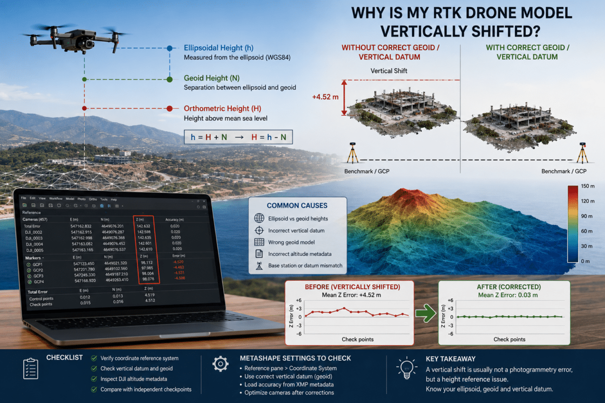
You process a survey captured with an RTK drone, the cameras align correctly, the point cloud looks excellent and the model appears internally consistent. Then you compare the result with surveyed checkpoints and discover that the entire project is several meters vertically shifted.
This is one of the most confusing problems in professional drone photogrammetry.
In many cases, a vertical shift in an RTK drone model in Agisoft Metashape does not mean that RTK failed or that the photogrammetric reconstruction is inaccurate. The problem may simply be that the drone coordinates and the survey reference data use different definitions of height.
The most common causes are differences between ellipsoidal and orthometric heights, an incorrect geoid or vertical datum, or incorrect altitude information stored in the drone image metadata.
This guide explains how these height systems work and what to check when your Metashape project is horizontally accurate but vertically offset.
Why Can an Accurate RTK Survey Be Vertically Shifted?
RTK positioning can provide very accurate camera coordinates, but a coordinate is only meaningful when its reference system is correctly understood.
Horizontal coordinates and vertical coordinates do not necessarily use the same type of reference.
A GNSS receiver normally determines height relative to a mathematical reference surface called an ellipsoid. Surveyors and engineering projects, however, often work with elevations referenced to mean sea level using a geoid model.
If ellipsoidal heights from the drone are compared directly with orthometric heights from survey control points, the horizontal position may look correct while the entire model appears vertically shifted.
This offset can be several meters or even several tens of meters depending on geographic location.
Ellipsoidal Height vs Orthometric Height
To understand the problem, it is necessary to distinguish three values:
- h = ellipsoidal height
- H = orthometric height, often described as height above mean sea level
- N = geoid undulation or geoid separation
The relationship is commonly expressed as:
h = H + N
or:
H = h – N
The GNSS receiver primarily works with the ellipsoid, while many conventional survey benchmarks use orthometric elevations.
Imagine that an RTK drone reports an ellipsoidal height of 142 meters and the geoid separation in the survey area is approximately 47 meters.
The corresponding orthometric height would be approximately:
142 m – 47 m = 95 m
If you compare the 142-meter ellipsoidal coordinate directly with a checkpoint measured at approximately 95 meters above the relevant vertical datum, the project may appear to have a vertical error of about 47 meters even though both measurements are correct within their respective reference systems.
How Metashape Interprets Camera Altitudes
This is particularly important when processing RTK imagery in Agisoft Metashape Professional.
By default, Metashape assumes that altitude values loaded into the Reference pane are heights estimated from the corresponding ellipsoid.
If your coordinates instead use heights referenced to a geoid, the project must use the appropriate vertical coordinate system.
Metashape Professional supports configurable vertical datums based on geoid undulation grids, allowing horizontal and vertical coordinate references to be combined correctly.
Failing to configure the correct vertical reference can result in a model that is internally accurate but vertically inconsistent with your control points or GIS data.
What Is a Geoid?
The Earth is not a perfect sphere or a perfectly regular ellipsoid.
A geoid is an irregular gravity-based reference surface that approximately represents global mean sea level and its continuation beneath the continents.
Because the geoid and ellipsoid are different surfaces, their separation varies geographically.
This means you cannot solve an ellipsoid-versus-geoid problem by applying one universal global correction value.
The correct geoid model for the project location and coordinate reference system should be used.
How to Use a Geoid in Agisoft Metashape
Agisoft Metashape Professional supports vertical coordinate systems and geoid models.
If the required geoid is available, it can be installed and associated with the appropriate horizontal coordinate system to create a compound coordinate reference system.
In Metashape, open the coordinate system selection from the Reference pane settings and select or configure the coordinate system that combines:
- The correct horizontal coordinate reference system
- The appropriate vertical coordinate system
- The corresponding geoid model
Once the correct vertical datum is applied, Metashape can correctly transform between the ellipsoid-based and geoid-based height references where the required transformation data is available.
DJI AbsoluteAltitude vs RelativeAltitude
Another potential source of vertical errors is the altitude information stored inside DJI image metadata.
DJI images can contain two important altitude values:
- AbsoluteAltitude
- RelativeAltitude
RelativeAltitude represents the aircraft height relative to the take-off point.
AbsoluteAltitude is intended to provide an absolute altitude value associated with the image.
Agisoft has documented cases where the AbsoluteAltitude value recorded in the image metadata may be incorrect.
Metashape reads the available metadata and uses these values in the Reference pane. It does not automatically know whether an incorrect altitude recorded by the aircraft should be replaced with another value.
This means a dataset can appear to have precise GPS information while still containing an incorrect vertical reference.
How to Check DJI Altitude Metadata in Metashape
After importing your images, open the Reference pane and inspect the camera coordinates.
Look carefully at the altitude values.
Ask yourself:
- Are the heights realistic for the survey location?
- Are they approximately equal to the expected terrain elevation plus flight height?
- Are they ellipsoidal heights or orthometric heights?
- Were the survey checkpoints measured using the same vertical reference?
- Does the vertical error remain approximately constant throughout the project?
A nearly constant vertical offset across multiple independent checkpoints is an important clue.
If every checkpoint shows approximately the same vertical difference, the issue may be related to a height reference, geoid or systematic altitude offset rather than poor photogrammetric reconstruction.
What If DJI AbsoluteAltitude Is Wrong?
If the absolute altitude stored in DJI imagery is incorrect, one possible workflow is to use the RelativeAltitude value together with the known ellipsoidal height of the take-off point.
Conceptually:
Camera ellipsoidal height = take-off point ellipsoidal height + RelativeAltitude
Agisoft provides Python scripts for reading DJI altitude metadata and applying a known altitude offset to camera coordinates.
After correcting camera reference altitudes, the updated coordinates should be applied before continuing with the final optimization and generation of survey products.
Always retain the original project or coordinate data before applying bulk altitude corrections.
RTK Does Not Automatically Mean Orthometric Height
This misunderstanding is particularly common with modern RTK drones.
Seeing an RTK FIX status does not automatically mean that the elevation stored in every image is already expressed as height above mean sea level.
RTK primarily improves the precision of the GNSS position.
The user must still understand:
- The coordinate reference system
- The GNSS datum
- The ellipsoid
- The vertical datum
- The geoid model
- How the drone stores altitude metadata
A highly precise coordinate referenced to the wrong vertical system can still produce a large apparent error when compared with survey data using another height reference.
Why Are My Horizontal Coordinates Correct but Elevation Wrong?
This is one of the strongest indicators of a vertical reference problem.
Suppose your independent checkpoints show centimeter-level horizontal differences but every vertical measurement is several meters too high or too low.
The photogrammetric reconstruction may still be very good.
Before changing alignment parameters, rebuilding the point cloud or assuming the RTK system failed, check whether the camera coordinates and checkpoints use the same vertical reference.
A systematic Z offset is fundamentally different from random elevation errors across the project.
Constant Vertical Shift vs Variable Vertical Error
The pattern of the error can help identify its cause.
Approximately Constant Vertical Shift
If most checkpoints show a similar Z offset, investigate:
- Ellipsoidal vs orthometric heights
- Incorrect or missing geoid model
- Wrong vertical datum
- DJI AbsoluteAltitude metadata
- A constant base station or coordinate offset
Variable Vertical Errors
If vertical errors vary significantly across the survey area, investigate additional factors such as:
- Weak camera geometry
- Poor image overlap
- RTK quality variations
- Incorrect camera accuracy settings
- Camera calibration
- Rolling or systematic deformation
- Incorrect Ground Control Point measurements
Changing the geoid will not normally fix a photogrammetric model that is geometrically distorted.
How to Troubleshoot a Vertical Shift in Metashape
A practical troubleshooting workflow is:
- Check the camera altitude values in the Reference pane.
- Confirm what height type the drone coordinates use.
- Confirm what vertical datum the checkpoints or GCPs use.
- Check whether the Z offset is approximately constant.
- Verify the project coordinate system.
- Configure the appropriate vertical datum or geoid model if required.
- Check DJI AbsoluteAltitude and RelativeAltitude metadata.
- Correct invalid camera altitude data where necessary.
- Update the reference information and optimize cameras again.
- Validate the corrected project using independent checkpoints.
Why Checkpoints Are Essential with RTK Drones
RTK significantly improves camera positioning, but independent checkpoints remain one of the best ways to verify the actual accuracy of the completed photogrammetric project.
A checkpoint has known surveyed coordinates but is not used to constrain the model during adjustment.
Comparing Metashape results with checkpoints can reveal:
- Horizontal bias
- Vertical bias
- Incorrect coordinate systems
- Vertical datum problems
- Unexpected deformation
Without independent checkpoints, a project can appear precise internally while still containing a systematic absolute offset.
Do GCPs Fix an Ellipsoid vs Geoid Problem?
Ground Control Points can constrain the model to known coordinates, but they should not be used as a substitute for understanding the project’s coordinate reference systems.
If camera coordinates and GCP coordinates use different vertical datums without the correct transformation, the project contains inconsistent reference information.
The better approach is to ensure that camera coordinates, GCPs, checkpoints and project outputs are handled using correctly defined horizontal and vertical reference systems.
Final Recommendations
If your RTK drone model is vertically shifted in Agisoft Metashape, do not immediately assume that the RTK drone, camera calibration or photogrammetric processing has failed.
First determine whether all coordinates use the same definition of height.
In particular, check:
- Whether camera heights are ellipsoidal or orthometric
- Which vertical datum is used by your survey control
- Whether the correct geoid model is available
- Whether DJI AbsoluteAltitude metadata is valid
- Whether the vertical offset is constant across checkpoints
- Whether the Metashape project uses the correct coordinate system
For professional surveying workflows, correctly managing the vertical reference system is just as important as obtaining an RTK FIX during the flight.
Once the ellipsoid, geoid and vertical datum are correctly understood and configured, Agisoft Metashape Professional can combine RTK camera coordinates, GCPs, checkpoints and configurable vertical datums to produce accurately georeferenced photogrammetric results.
Frequently Asked Questions
Why is my Metashape model several meters too high or too low?
A systematic vertical offset can be caused by using ellipsoidal camera heights together with orthometric survey heights, an incorrect vertical datum, a missing geoid model or incorrect altitude metadata.
What is the difference between ellipsoidal and orthometric height?
Ellipsoidal height is measured relative to a mathematical ellipsoid used by GNSS systems. Orthometric height is measured relative to a gravity-based vertical reference associated with the geoid and is commonly used to represent elevation above mean sea level.
Does RTK provide height above sea level?
Not automatically. GNSS positioning fundamentally produces ellipsoid-referenced coordinates. A geoid model and vertical coordinate reference are required when converting those values to an orthometric height system.
Can Agisoft Metashape use geoid models?
Yes. Metashape Professional supports configurable vertical datums based on geoid undulation grids and compound coordinate systems.
Why are my RTK horizontal coordinates accurate but altitude is wrong?
If horizontal accuracy is good but the entire project has a similar vertical offset, check the vertical datum, ellipsoid-versus-geoid height definition and drone altitude metadata before changing photogrammetric processing settings.
What is DJI RelativeAltitude?
RelativeAltitude represents the aircraft height relative to its take-off point. It should not be confused with an absolute ellipsoidal or orthometric elevation.
