

 Italiano
 Français
 Deutsch
 Español
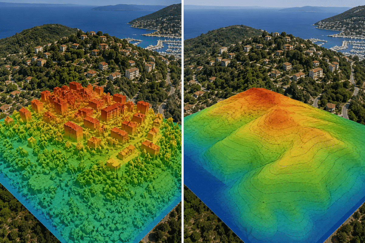
Understanding the difference between a DSM and DTM in Agisoft Metashape is essential for anyone using drone photogrammetry for surveying, construction, mining, engineering, forestry or GIS applications.
Both products represent elevation, but they describe very different surfaces. A Digital Surface Model includes objects such as buildings, trees and vehicles, while a Digital Terrain Model is designed to represent the underlying bare-earth terrain.
Choosing the wrong elevation model can significantly affect measurements, contour lines, drainage analysis, cut-and-fill calculations and other geospatial results.
In this guide, we explain the difference between DSM vs DTM in Agisoft Metashape, when each model should be used and the correct workflow for creating both from drone imagery.
What Is a DSM?
A Digital Surface Model (DSM) represents the elevation of the visible surface captured by the drone or camera.
This means that the elevation model can include:
- Buildings
- Trees and vegetation
- Vehicles
- Construction equipment
- Stockpiles
- Rock formations
- Other objects visible in the images
If a drone flies over an urban area, for example, the roof of a building becomes part of the DSM because it is the surface visible from above.
The same applies to tree canopies in a forest or machinery operating on a construction site.
A DSM is therefore useful whenever the height of the complete visible surface is important.
What Is a DTM?
A Digital Terrain Model (DTM) is intended to represent the elevation of the underlying ground rather than the top of objects located above it.
Buildings, vegetation, vehicles and other non-ground objects should therefore be excluded from the terrain model.
This makes a DTM particularly useful for:
- Topographic mapping
- Contour generation
- Road design
- Construction planning
- Earthworks
- Cut-and-fill calculations
- Drainage analysis
- Hydrological modeling
- Mining and quarry surveys
In Agisoft Metashape Professional, producing a proper DTM generally requires the point cloud to be classified so that ground points can be separated from above-ground objects.
DSM vs DTM: What Is the Main Difference?
The easiest way to understand the difference is to imagine a drone survey over a building surrounded by trees.
In the DSM, the elevation surface follows the top of the roof, the tree canopies and the surrounding ground.
In the DTM, the objective is to remove the building and vegetation and reconstruct the terrain that lies underneath or around them.
| Feature | DSM | DTM |
|---|---|---|
| Represents visible surface | Yes | No |
| Includes buildings | Yes | No |
| Includes vegetation | Yes | No |
| Represents bare earth | No | Yes |
| Useful for 3D surface analysis | Yes | Sometimes |
| Useful for terrain contours | Limited | Yes |
| Useful for cut and fill | Depends on project | Usually preferred |
| Requires ground classification | Not normally | Yes |
How to Create a DSM in Agisoft Metashape
The DSM workflow is generally simpler because the objective is to preserve the visible reconstructed surface.
Step 1: Align the Photos
Import the drone images and select:
Workflow > Align Photos
Metashape calculates camera positions and generates the initial photogrammetric reconstruction.
Before continuing, verify that the cameras are correctly aligned and that the project uses the appropriate coordinate reference system.
Step 2: Build the Point Cloud
For workflows requiring a point cloud, select:
Workflow > Build Point Cloud
The point cloud represents the reconstructed surface visible in the photographs and can contain terrain, roofs, trees and other objects.
Step 3: Build the DEM
Select:
Workflow > Build DEM
Choose the appropriate source data and include the surface information required for the project.
Because the objective is to generate a DSM, above-ground objects remain part of the elevation model.
Once generated, the DSM can be inspected in the Ortho view and exported for GIS or engineering applications.
How to Create a DTM in Agisoft Metashape
The DTM workflow requires an additional classification stage because buildings, trees and other objects need to be separated from the terrain.
Step 1: Build the Point Cloud
After photo alignment and optimization, create the point cloud using:
Workflow > Build Point Cloud
Step 2: Classify Ground Points
Select:
Tools > Point Cloud > Classify Ground Points
Metashape analyzes the point cloud and automatically attempts to identify points that belong to the terrain.
The classification process uses parameters such as Max Angle, Max Distance, Max Terrain Slope, Cell Size and Erosion Radius.
There is no universal combination of values that works perfectly for every dataset. Flat agricultural land, dense forest, urban areas and steep quarries require different classification settings.
Step 3: Check the Ground Classification
Automatic classification should be treated as a starting point rather than blindly accepted as the final result.
Inspect areas around buildings, walls, vegetation, embankments, excavation edges and steep terrain.
If necessary, manually reassign incorrectly classified points before generating the DTM.
Step 4: Build the DTM
Select:
Workflow > Build DEM
Use the point cloud as the source and select the Ground class for the terrain model. Additional appropriate classes, such as Road, can be included when required by the project.
The resulting elevation model will be based on the points identified as terrain rather than the complete visible surface.
Which Is Better for an Orthomosaic: DSM or DTM?
Both DSM and DTM data can be useful when generating orthomosaics, but the correct choice depends on the type of project.
For urban environments and areas containing significant above-ground structures, preserving surface geometry can be important for correct image projection.
For projects where the objective is a terrain-oriented orthomosaic, a DTM may provide a more appropriate reference surface.
Metashape Professional supports georeferenced elevation models and orthomosaic generation as part of the professional mapping workflow.
DSM or DTM for Construction?
Construction projects often require both.
A DSM can document the complete visible state of a construction site, including structures, equipment, material piles and temporary features.
A DTM is more appropriate when engineers need to analyze the underlying terrain, compare design elevations or perform earthwork calculations.
For example, a contractor monitoring a site over time may use a DSM to document current surface conditions but use terrain models for excavation and grading analysis.
DSM or DTM for Stockpile Volumes?
For stockpile calculations, the correct elevation model depends on what is being measured and the reference surface used for the volume calculation.
A stockpile itself is an above-ground object, so automatically removing it as part of a bare-earth classification would obviously eliminate the feature that needs to be measured.
For this reason, volume calculations should be based on a surface that retains the stockpile geometry while using an appropriate base plane or reference surface for the calculation.
This is a good example of why a DTM is not automatically the correct choice for every professional mapping task.
DSM or DTM for Contour Lines?
When contour lines are intended to represent the actual terrain, a DTM is normally the better choice.
If contours are generated directly from a DSM in an urban or vegetated environment, they may follow roofs, trees and other above-ground objects.
This can create contour lines that do not represent the real topography of the site.
Ground classification before contour generation can therefore be critical for topographic surveys.
Can Photogrammetry See the Ground Under Trees?
This is an important limitation to understand when creating DTMs from aerial photographs.
Photogrammetry reconstructs surfaces that are visible in the source images.
If dense vegetation completely hides the ground, the drone camera does not record the terrain underneath the canopy. Metashape cannot directly reconstruct ground detail that is absent from the photographs.
Ground classification can remove vegetation points and interpolate between available ground points, but it cannot create measured terrain data where the ground was never visible.
For heavily forested terrain, airborne LiDAR may therefore be more suitable because laser returns can sometimes reach the ground through gaps in vegetation.
How Accurate Are DSM and DTM Models?
The accuracy of both models depends on the quality of the complete photogrammetric workflow.
Important factors include:
- Flight altitude
- Ground Sampling Distance (GSD)
- Image overlap
- Camera quality
- Image sharpness
- RTK or PPK positioning
- Ground Control Points
- Checkpoint accuracy
- Camera calibration
- Point cloud quality
- Ground classification quality
A DTM can be well classified but still inaccurate if the original project has poor georeferencing.
For survey-grade applications, independent checkpoints should be used whenever possible to evaluate the absolute horizontal and vertical accuracy of the final model.
How to Export DSM and DTM from Metashape
Once the elevation model has been created, select:
File > Export > Export DEM
GeoTIFF is one of the most common formats because it preserves georeferencing and can be imported into applications such as QGIS and ArcGIS.
The resulting DSM or DTM can then be used for additional GIS, CAD, engineering and terrain-analysis workflows.
DSM vs DTM in Agisoft Metashape: Which Should You Use?
The correct model depends entirely on the information you need from the survey.
Choose a DSM when:
- You need the complete visible surface.
- Buildings and vegetation are relevant to the analysis.
- You are documenting existing site conditions.
- You need surface heights or obstacle information.
- You are working with structures or above-ground features.
Choose a DTM when:
- You need bare-earth elevations.
- You are generating terrain contour lines.
- You are analyzing drainage or slopes.
- You are working on road or infrastructure design.
- You need terrain data for earthworks or grading.
- Buildings and vegetation must be removed from the elevation model.
In many professional projects, the best solution is to generate both a DSM and a DTM from the same Metashape project. Each model answers a different set of questions and together they provide a more complete representation of the surveyed area.
Frequently Asked Questions
Can Agisoft Metashape create both DSM and DTM models?
Yes. Agisoft Metashape Professional supports georeferenced DSM and DTM generation. A DTM normally requires the point cloud to be classified so that the Ground class can be used for DEM generation.
Is a DEM the same as a DSM?
DEM is a general term for a digital elevation model. Depending on which surface is represented, an elevation model may function as a DSM or a bare-earth DTM.
Do I need ground classification for a DSM?
Normally no. A DSM is intended to preserve the visible surface, including buildings and vegetation. Ground classification becomes important when the objective is to create a bare-earth DTM.
Is a DTM better than a DSM?
Not necessarily. They serve different purposes. A DTM is better for terrain analysis, while a DSM is better when above-ground objects are part of the information you need.
Can I export a DSM or DTM from Metashape to QGIS?
Yes. Elevation models can be exported in georeferenced formats such as GeoTIFF and imported into GIS applications including QGIS and ArcGIS.
