

 Italiano
 Français
 Deutsch
 Español
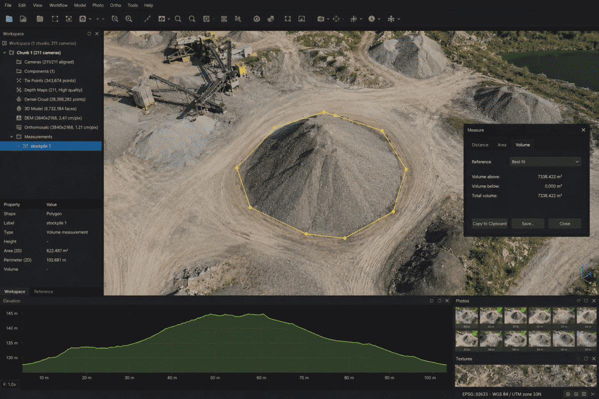
Calculating stockpile volumes in Agisoft Metashape is one of the most useful applications of drone photogrammetry for mining, construction, quarrying, aggregate management and earthworks.
Instead of measuring a stockpile manually, a drone survey can capture hundreds or thousands of overlapping photographs that are processed in Metashape Professional to create an accurate Digital Elevation Model (DEM). A polygon can then be drawn around the stockpile and its volume calculated relative to a defined reference plane.
However, obtaining reliable results requires more than simply drawing a boundary around the pile. Survey accuracy, image overlap, georeferencing, polygon placement and the choice of reference plane can all influence the final volume.
This guide explains how to calculate stockpile volume in Agisoft Metashape Professional, including the complete drone workflow and the differences between Best Fit, Mean Level and Custom Level volume calculations.
Can Agisoft Metashape Calculate Stockpile Volumes?
Yes. Agisoft Metashape Professional includes built-in tools for measuring coordinates, distances, areas and volumes.
For stockpile measurements, the typical workflow is:
- Capture overlapping drone images.
- Align the photographs in Metashape.
- Georeference and optimize the project.
- Build the point cloud or other required surface data.
- Create a Digital Elevation Model.
- Draw a polygon around the stockpile.
- Open the Measure tool.
- Select the appropriate reference plane.
- Read and export the calculated volume.
The volume measurement tool is available in Agisoft Metashape Professional and works with polygon shapes created over an elevation model.
Step 1: Capture the Stockpile with a Drone
Accurate stockpile measurements begin with good image acquisition.
The drone mission should provide consistent coverage of the complete stockpile, including the top, sides and surrounding ground.
A regular nadir mapping mission may be sufficient for relatively smooth stockpiles, but additional oblique imagery can improve reconstruction of steep slopes and complex edges.
Make sure that:
- The entire pile is visible in multiple images.
- There is sufficient image overlap.
- Photographs are sharp and correctly exposed.
- The surrounding ground is also captured.
- RTK, PPK or Ground Control Points are used when survey accuracy is required.
The area immediately around the stockpile is particularly important because Metashape may use the polygon boundary elevations to define the reference plane for volume calculation.
Step 2: Add and Align the Photos
Create a new project in Metashape Professional and import the images using:
Workflow > Add Photos
Then select:
Workflow > Align Photos
Metashape identifies common features between overlapping photographs and reconstructs the camera positions.
After alignment, inspect the project carefully.
Check that:
- All important cameras are aligned.
- The stockpile is completely reconstructed.
- No isolated camera groups are present.
- The project coordinate system is correct.
- Reference errors are reasonable.
Step 3: Georeference the Project
Volume is a metric measurement, so the project must have the correct scale.
For professional stockpile surveying, common georeferencing methods include:
- RTK drone camera coordinates
- PPK camera coordinates
- Ground Control Points
- Surveyed checkpoints
Independent checkpoints are useful for evaluating the actual accuracy of the photogrammetric model before relying on the calculated volume.
A visually impressive 3D model is not enough: if the model scale or elevation is incorrect, the resulting stockpile volume will also be incorrect.
Step 4: Build the Surface Model
After alignment and optimization, create the surface data required for the project.
A common workflow is:
Workflow > Build Point Cloud
followed by:
Workflow > Build DEM
The resulting Digital Elevation Model represents the elevation of the surveyed surface.
For stockpile measurements, it is important that the pile itself remains part of the surface.
Do not automatically remove the stockpile as a non-ground object if your objective is to measure its volume.
DSM or DTM for Stockpile Volume?
This is an important distinction.
A Digital Surface Model (DSM) preserves objects located above the terrain, including the stockpile itself.
A bare-earth Digital Terrain Model (DTM) attempts to remove above-ground features.
Because a stockpile is the object you want to measure, the surface used for the volume calculation must preserve the stockpile geometry.
The base underneath the stockpile is then estimated using the selected reference plane or another appropriate reference surface.
Step 5: Open the DEM in Ortho View
Double-click the DEM in the Workspace pane to open it in Ortho view.
This provides a top-down representation of the elevation model and makes it easier to define the stockpile boundary accurately.
You can use the orthomosaic as a visual reference while drawing the polygon, but the actual volume calculation is based on the elevation model.
Step 6: Draw a Polygon Around the Stockpile
Select the Draw Polygon tool from the toolbar.
Click around the base of the stockpile to define its boundary.
The quality of this polygon is extremely important.
Whenever possible, place the polygon vertices on the surrounding ground at the true base of the pile rather than on the slope itself.
A polygon that is too small may exclude material, while one that extends too far beyond the pile can introduce unnecessary terrain into the volume calculation.
Step 7: Calculate the Stockpile Volume
After drawing the polygon, right-click the shape and select:
Measure…
Open the:
Volume tab.
Metashape displays three supported reference plane options:
- Best Fit
- Mean Level
- Custom Level
The choice of plane can significantly affect the calculated volume, especially when the stockpile is located on sloping or irregular ground.
Best Fit Plane
The Best Fit option creates a reference plane based on the elevations of the polygon boundary vertices.
Unlike a simple horizontal plane, the Best Fit plane can follow the general inclination of the terrain around the pile.
This makes it particularly useful when a stockpile is sitting on relatively consistent but sloping ground.
For many stockpile surveys, Best Fit is a practical starting point because the base plane is derived from the elevations around the perimeter of the stockpile.
Mean Level Plane
The Mean Level option creates a horizontal reference plane based on the mean elevation of the polygon vertices.
This can work well when the ground underneath the stockpile is approximately level.
However, if the pile sits on a noticeable slope, a horizontal mean plane may not accurately represent the original terrain underneath the material.
In those cases, Best Fit may provide a more realistic approximation.
Custom Level Plane
The Custom Level option allows you to manually define the elevation of the reference plane.
This is particularly useful when:
- The stockpile sits on a known concrete slab.
- The base elevation is known from engineering drawings.
- You are monitoring the same stockpile area repeatedly.
- You need all surveys to use exactly the same reference elevation.
After entering the desired level, press Update to recalculate the volume.
Volume Above, Below and Total
Metashape reports several volume values.
Volume Above represents material located above the selected reference plane.
Volume Below represents portions of the DEM located below that plane.
Metashape also calculates a Total Volume that accounts for both values.
For a conventional stockpile sitting entirely above the reference base, Volume Above is normally the value of primary interest.
If the reference plane intersects the terrain or the stockpile base is irregular, both above and below values may appear.
Which Reference Plane Should You Use?
| Base Condition | Recommended Starting Point |
|---|---|
| Level concrete pad | Mean Level or Custom Level |
| Known engineering elevation | Custom Level |
| Stockpile on sloping ground | Best Fit |
| Regular repeated surveys | Custom Level |
| Unknown but relatively uniform base | Best Fit |
There is no single reference plane that is correct for every stockpile.
The best choice depends on the physical surface underneath the material.
Stockpiles on Sloping or Irregular Ground
Stockpiles located on sloping terrain are more challenging because the original surface underneath the pile is not directly visible.
The Best Fit plane can approximate a general slope using the boundary elevations, but it cannot reconstruct complex terrain hidden underneath the stockpile.
If high accuracy is required and the original surface is available from an earlier drone survey, a better approach may be to compare the current surface with a previously surveyed base surface.
This can provide a more realistic representation of the actual ground underneath the material than a simple planar approximation.
How to Improve Stockpile Volume Accuracy
Several factors influence the reliability of the final measurement.
Use Accurate Georeferencing
RTK, PPK or well-distributed Ground Control Points can improve the absolute scale and position of the model.
Use Independent Checkpoints
Checkpoints allow you to evaluate the accuracy of the completed project rather than relying only on the estimated camera errors.
Capture the Complete Stockpile
Missing imagery around steep faces can create incomplete geometry and reduce volume accuracy.
Draw the Polygon Carefully
Place the stockpile boundary as close as possible to the true intersection between the pile and surrounding terrain.
Choose the Correct Base Plane
A very accurate photogrammetric surface can still produce the wrong stockpile volume if the assumed base does not represent the real ground underneath the material.
Can You Calculate Stockpile Volume Without GCPs?
Yes.
A properly functioning RTK or PPK drone can provide accurately georeferenced camera positions without requiring Ground Control Points for every project.
However, whether the resulting accuracy is sufficient depends on the survey requirements.
For commercial inventory, mining or engineering applications, independent checkpoints are strongly recommended whenever the volume measurement must be validated.
How to Monitor Stockpile Volume Over Time
Metashape can also be used for recurring stockpile surveys.
For consistent comparisons:
- Use the same coordinate reference system.
- Maintain similar flight parameters.
- Use consistent georeferencing methods.
- Use the same stockpile boundary where appropriate.
- Use the same Custom Level or reference surface.
Using a consistent Custom Level is particularly useful because the volume can be recalculated against exactly the same reference elevation during each survey.
Exporting the Volume Measurement Report
After calculating the volume, Metashape allows the measurement report to be saved.
The report can include information such as:
- Polygon
- Elevation model
- Perimeter
- Area
- Volume above
- Volume below
- Total volume
Reports can be saved in formats including PDF and HTML, making it easier to document stockpile measurements for clients, project managers or inventory records.
Common Stockpile Volume Measurement Mistakes
Drawing the Polygon on the Stockpile Slope
If the boundary vertices are placed too high on the pile, the calculated Best Fit or Mean Level reference plane may also be too high.
Using Mean Level on Strongly Sloping Ground
A horizontal plane may poorly represent a sloped stockpile base.
Removing the Stockpile During Ground Classification
If the stockpile is classified as a non-ground object and excluded from the elevation surface used for measurement, the material you want to measure may disappear from the DEM.
Ignoring Project Accuracy
Volume calculations depend on the scale and geometry of the photogrammetric model. Always check survey quality before using the result commercially.
Using Different Reference Levels Between Surveys
If repeated inventory surveys use different base planes, apparent volume changes may be caused partly by the measurement method rather than actual material movement.
Final Recommendations
Calculating stockpile volume in Agisoft Metashape is straightforward once the photogrammetric model and DEM have been correctly generated.
The essential workflow is:
- Capture high-quality overlapping drone imagery.
- Align and georeference the photographs.
- Verify survey accuracy.
- Build the required surface and DEM.
- Open the DEM in Ortho view.
- Draw a polygon accurately around the stockpile base.
- Right-click the polygon and select Measure.
- Open the Volume tab.
- Select Best Fit, Mean Level or Custom Level.
- Review and export the volume results.
The most important decision is often not the volume calculation itself, but selecting a reference plane that realistically represents the surface underneath the stockpile.
With accurate drone imagery, appropriate georeferencing and a correctly defined base surface, Agisoft Metashape Professional provides an efficient workflow for recurring stockpile inventory, quarry management, construction monitoring and earthwork measurements.
Frequently Asked Questions
Can Agisoft Metashape calculate stockpile volumes?
Yes. Metashape Professional includes DEM-based volume measurement tools that can calculate the volume inside a polygon relative to a selected reference plane.
How do I measure a stockpile volume in Metashape?
Create a DEM, open it in Ortho view, draw a polygon around the stockpile, right-click the polygon, select Measure and open the Volume tab.
What is Best Fit volume in Metashape?
Best Fit creates a reference plane based on the elevations of the polygon boundary vertices. It is useful when the ground beneath a stockpile has a general slope.
What is Mean Level in Metashape?
Mean Level creates a horizontal reference plane based on the mean altitude of the polygon vertices.
What is Custom Level used for?
Custom Level allows you to specify an exact reference elevation. It is particularly useful for known base elevations and repeat stockpile surveys.
Do I need a DEM to calculate stockpile volume?
Yes. Metashape’s DEM-based volume measurement workflow requires an elevation model and a polygon defining the measurement area.
Can I calculate stockpile volume without GCPs?
Yes. RTK or PPK camera coordinates can provide project georeferencing without GCPs, although independent checkpoints are recommended when survey accuracy must be verified.
Can Metashape export a stockpile volume report?
Yes. Measurement reports can be saved in PDF and HTML formats and can include area, perimeter, elevation information and volume results.
