

 Italiano
 Français
 Deutsch
 Español
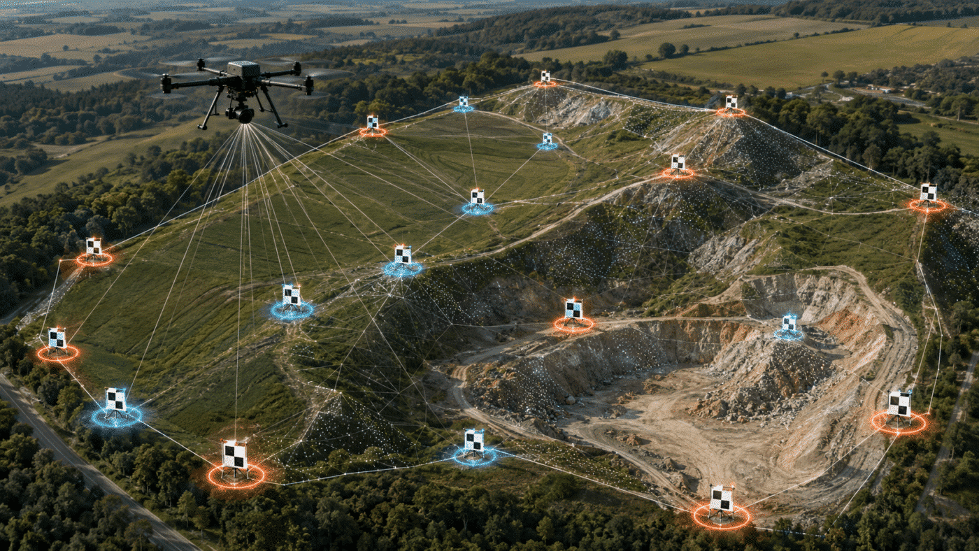
Ground Control Points and check points perform different jobs in Agisoft Metashape. GCPs constrain and georeference the photogrammetric solution, while check points are excluded from optimization and used to test its accuracy. Using every surveyed target as a GCP may produce reassuringly small residuals, but it leaves you without an independent measurement of how accurate the final map really is.
The right number and distribution depend on the project geometry, terrain, camera-position accuracy, required deliverables and applicable accuracy standard. This guide explains how to divide your surveyed points between control and validation, where to place them, how to configure them in Agisoft Metashape Professional and which error patterns should trigger further investigation.
Contents
GCPs vs Check Points in Metashape: The Quick Answer
For a conventional drone survey without precise RTK/PPK camera coordinates, a practical starting configuration is often five to ten well-distributed GCPs plus at least three to five independent check points. For an RTK/PPK flight, fewer or no GCPs may be required if the camera coordinates are reliable, but independent check points remain important. These are planning ranges, not universal acceptance rules.
| Point type | Role in Metashape | Used in optimization? | Main result |
|---|---|---|---|
| Ground Control Point | References, scales and constrains the model | Yes | Control-point residual |
| Check point | Tests the adjusted model at an independently surveyed location | No | Validation residual and RMSE |
| Camera reference | Supplies approximate or precise camera positions from GNSS/RTK/PPK | When enabled | Camera-location residual |
| Tie point | Connects overlapping images during alignment | Yes | Image reprojection residual |
The best layout normally includes control near the perimeter, control in the interior and points at different elevations. Check points should sample the same project area without being clustered beside the GCPs. Long corridors, steep terrain and irregular survey blocks need geometry-specific placement rather than a simple points-per-hectare rule.
What Is the Difference Between a GCP and a Check Point?
Ground Control Points Constrain the Solution
A Ground Control Point is a clearly identifiable location whose real-world coordinates have been measured independently, normally using survey-grade GNSS or a total station. When the point is enabled in the Metashape Reference pane, its coordinates participate in bundle adjustment. Metashape adjusts camera parameters, tie-point positions and the model transformation while considering the marker coordinates and their assigned accuracy.
GCP residuals tell you how well the adjusted model fits the control observations. They are valuable for detecting blunders and evaluating the control network, but they are not an independent product-accuracy test because the same coordinates helped create the result.
Check Points Validate the Solution
A check point is also a surveyed marker visible in the images, but its checkbox is disabled in the Reference pane. Its coordinate is withheld from the final optimization. Metashape can therefore compare the photogrammetrically estimated position with the independent survey coordinate.
Agisoft’s official documentation states that control points are used to reference the model, whereas check points validate camera alignment and optimization results. It recommends retaining at least three to five points for accuracy assessment. See Control and Check Points for Aerial Surveys.
The terms check point and checkpoint are often used interchangeably in photogrammetry. Metashape documentation commonly uses “check point,” while mapping standards and research papers may use the single-word form.
Why Using Every Target as a GCP Is a Mistake
If all surveyed markers constrain the model, the report can show low control residuals without revealing how the solution behaves at independent locations. This is especially risky when control points are clustered, camera calibration is weak or a systematic deformation occurs between them.
A low GCP error answers: How well does the solution fit its control? A low checkpoint error answers the more useful validation question: How well does the solution predict coordinates it was not allowed to use? For the full interpretation of RMSE and marker tables, read Agisoft Metashape Processing Report Explained.
How Many GCPs and Check Points Do You Need?
There is no universal number based only on hectares, image count or GSD. The point network must be strong enough to control the geometry and large enough to test the required accuracy. A ten-hectare flat rectangular field and a ten-hectare quarry with multiple benches do not require the same layout.
The following table provides practical starting ranges for planning. Final requirements should be defined by the survey specification, local regulations and the professional responsible for the deliverable.
| Survey scenario | Practical GCP starting point | Check-point strategy |
|---|---|---|
| Small, regular, relatively flat block without RTK/PPK | Approximately 5–8, including perimeter and interior control | At least 3–5 independent points distributed across the block |
| Medium or irregular block without precise camera positions | Approximately 8–15, adjusted for shape and terrain | At least 5, with more for stronger statistics and coverage |
| RTK/PPK block with verified centimetre-level camera coordinates | 0–4 may be sufficient for bias control or redundancy; test before deciding | At least 3–5; preferably more for a defensible accuracy statement |
| Long corridor | Control near both ends and at intervals, bends and elevation transitions | Interleaved along the corridor, not concentrated at one end |
| Steep, terraced or complex terrain | Control at multiple elevations, edges and deformation-prone zones | Independent points on upper, middle and lower surfaces |
| Project requiring formal standards compliance | Determined by the adjustment design and specification | Use the checkpoint quantity and sampling rules required by the applicable standard |
Do not treat these ranges as guarantees. Five excellent GCPs can outperform fifteen poorly measured or badly placed points, but too few points provide little redundancy and make blunders harder to detect. Recent peer-reviewed research confirms that reliability, quantity and distribution interact, with errors often appearing around edges and areas of strong topographic variation. See the study on GCP reliability and distribution in UAV photogrammetric mapping.
Minimum Operational Check Points vs Standards-Compliant Validation
Agisoft’s recommendation of three to five assessment points is a useful operational minimum for evaluating a Metashape project. It is not automatically sufficient for contractual or statistically rigorous accuracy certification.
For example, the current ASPRS Positional Accuracy Standards use larger independent samples; Edition 2 increased the minimum checkpoint count for a fully compliant product assessment to 30. Other countries, clients and applications may specify different methods. Always follow the standard named in the contract.
How Should You Divide a Limited Number of Surveyed Targets?
If only ten high-quality targets are available in a conventional non-RTK block, using approximately six or seven as control and three or four as check points may be more informative than enabling all ten. With twelve targets, a seven-and-five or eight-and-four division can provide stronger independent testing. The exact split should preserve good geometry for both groups.
Do not choose check points merely from the least convenient or lowest-quality targets. Control and validation points should be measured to comparable standards. A poor checkpoint survey tests the field measurement as much as it tests the photogrammetry.
Where Should You Place GCPs and Check Points?
1. Control the Perimeter
Place GCPs near the corners and outer limits of a block, without putting them so close to the image boundary that they are visible in too few photographs. Edge control helps prevent horizontal and vertical deformation outside a central cluster.
2. Add Interior Control
A perimeter-only layout may leave the centre weak, particularly in large blocks or where camera calibration and terrain vary. Add one or more interior points according to the area, shape and expected deformation. Research has repeatedly shown that both edge coverage and distributed control matter.
3. Cover the Elevation Range
Do not place every point on the same flat surface when the project includes slopes, quarry benches, embankments, roofs or deep excavations. Include control and validation at high, middle and low elevations. This strengthens the three-dimensional geometry and makes vertical bias easier to detect.
4. Avoid Collinear or Clustered Networks
Points arranged along one line provide weak two-dimensional coverage. Similarly, five markers within one small corner do not control the rest of the block. Spread observations in X, Y and Z while maintaining adequate image visibility.
5. Interleave Check Points with GCPs
Check points should test areas between and beyond the control locations. Do not place each checkpoint immediately beside a GCP, because both positions will experience almost the same local geometry. Include checkpoints near the centre, edges and elevation changes while keeping them inside reliable image coverage.
6. Treat Corridors Differently
Roads, railways, pipelines, rivers and power lines require longitudinal control. Place points near both ends, then at suitable intervals and around bends, junctions or height changes. Alternate control and check points along the route. A cluster at the launch point cannot reveal drift at the far end.
7. Use Targets That Are Visible and Unambiguous
A target must be large enough to resolve clearly at the planned GSD, high contrast against its surroundings and stable throughout the flight. Avoid moving vegetation, loose materials, shadows, reflective surfaces and features whose centre is ambiguous. The surveyed point must correspond exactly to the pixel location marked in every image.
Before fieldwork, calculate the expected GSD and inspect the planned altitude. Our Agisoft Metashape aerial survey tips explain how flight height, image resolution and capture geometry affect the resulting dataset.
Do RTK and PPK Drones Still Need GCPs?
High-quality RTK or PPK camera coordinates can substantially reduce the number of GCPs required for georeferencing. In a well-designed flight with verified FIX solutions, correct antenna offsets, accurate timestamps and consistent coordinate systems, a project may be processed without conventional GCPs.
That does not eliminate the need for independent validation. Check points reveal GNSS bias, vertical-datum mistakes, lever-arm errors and systematic block deformation that camera reference residuals alone may not expose. A sensible RTK/PPK test is to process a duplicate chunk with camera coordinates and check points only, then compare the results with a version that includes limited ground control.
See Metashape + RTK/PPK Drones: How to Maximize Accuracy for camera accuracy, source preselection and optimization guidance.
How to Configure GCPs and Check Points in Metashape
- Import the marker coordinates. Use the Import command in the Reference pane and map the label, X, Y, Z and accuracy columns correctly.
- Confirm the coordinate reference system. Check horizontal units, axis order, ellipsoid and vertical datum before optimization.
- Assign realistic marker accuracy. Use values supported by the GNSS or total-station method. If XY and Z accuracies differ, configure them separately.
- Place each marker precisely. Agisoft recommends identifying a marker in at least three images. Add more clear projections with good geometry and verify every automatically refined position.
- Choose the roles. Enable the checkbox for GCPs and disable it for check points. Since Metashape 2.2.1, the two roles use different icons.
- Optimize using control only. Run Optimize Cameras with the selected control and reference observations.
- Update and inspect the Reference pane. Review X, Y, Z, total coordinate errors and marker image residuals.
- Export a processing report. Record the point roles, accuracies, coordinate systems, RMSE and largest checkpoint residual.
For the complete import and marking procedure, follow How to Use GCPs in Agisoft Metashape. Agisoft also provides an official aerial data processing workflow with GCPs.
Important: Decide Check Points Before Final Optimization
A genuinely independent checkpoint must not influence the final adjusted solution. Assign the roles before the final optimization. If you convert a former GCP into a check point, disable it and rerun the appropriate optimization so the final model no longer uses that coordinate as control. For rigorous comparisons, duplicate the aligned chunk and document the control configuration applied to each version.
How to Interpret GCP and Check-Point Errors
| Observed result | Possible meaning | Recommended check |
|---|---|---|
| Low GCP error and low checkpoint error | Control fit and independent validation are consistent | Confirm that tolerances, sample size and point distribution meet the specification |
| Low GCP error and high checkpoint error | Possible overfitting, weak distribution or systematic deformation | Inspect checkpoint survey, calibration, edges, terrain and control layout |
| High GCP and checkpoint errors | Reference, marking, CRS or alignment problem | Verify coordinates, labels, datum, marker projections and camera model |
| Good XY but poor Z | Weak vertical geometry or height-system mismatch | Check geoid, ellipsoidal heights, elevation distribution and flight geometry |
| One extreme residual | Possible field or image-marking blunder | Audit the point independently; do not delete it only to improve RMSE |
| Errors increase toward an edge | Insufficient perimeter control or weak image coverage | Add or reposition control and improve capture geometry where possible |
Marker image error and coordinate error are different. A high image residual in pixels often indicates inaccurate marker placement in one or more photos. A low image residual combined with a large XYZ residual can indicate an incorrect surveyed coordinate, point label or datum. Reprojection error should also be evaluated, but a low tie-point residual does not guarantee external accuracy. Learn more in Reprojection Error in Agisoft Metashape: What Is a Good Value?
If vertical residuals show a nearly constant offset, verify whether the camera and marker coordinates use ellipsoidal or orthometric heights. Our step-by-step guide to geoids in Metashape explains this common source of Z error.
Field and Processing Checklist
- Define the required horizontal and vertical accuracy before choosing point quantities.
- Measure every control and checkpoint with an appropriately accurate method.
- Use unique marker labels and verify CSV column order.
- Distribute control around the perimeter, through the interior and across elevations.
- Interleave independent check points without clustering them beside GCPs.
- Keep targets inside strong multi-image coverage.
- Assign realistic XY and Z accuracy values.
- Check marker projections at high zoom in at least three images.
- Exclude check points from the final adjustment.
- Report RMSE, maximum residual, point count, spatial distribution, CRS and vertical datum.
Use this checklist together with our broader guide to quality checks for photogrammetry projects in Metashape.
Frequently Asked Questions
Is a check point the same as a GCP in Metashape?
The physical target and survey method may be identical, but the processing role is different. An enabled GCP constrains the model; a disabled check point validates it without participating in optimization.
What is the minimum number of check points recommended by Agisoft?
Agisoft recommends at least three to five points from which an accuracy assessment can be performed. Contracts and formal mapping standards may require substantially more.
Can I use only three GCPs?
Three non-collinear points may provide basic geometric control in some circumstances, but this offers little redundancy and is rarely a robust default for professional drone mapping. Additional well-distributed control makes blunders and deformation easier to detect.
Should check points be placed outside the GCP perimeter?
They should test the edges and spaces between control points, but they must remain within reliable image coverage. A checkpoint at the extreme edge of weak coverage may measure extrapolation conditions rather than the quality expected across the core deliverable.
Do RTK drones eliminate the need for check points?
No. RTK/PPK can reduce or eliminate conventional GCPs when camera coordinates are reliable, but independent check points are still needed to verify GNSS bias, datum configuration and final product accuracy.
Can I change a GCP into a check point after optimization?
Yes, by disabling its checkbox, but rerun the relevant optimization before treating it as independent. For defensible testing, establish point roles before the final adjustment and retain a documented processing configuration.
Conclusion
The strongest Metashape project does not simply use as many GCPs as possible. It uses enough reliable, well-distributed control to stabilize the block and preserves enough independent check points to test the result honestly.
Start with the survey geometry and accuracy requirement. Place control around the perimeter, inside the block and across the elevation range. Distribute check points through the same area without allowing them to influence optimization. Then evaluate horizontal and vertical errors separately and report both average and maximum residuals.
For professional georeferencing, checkpoint analysis and survey deliverables, explore Agisoft Metashape Professional Edition or visit the downloads page.
