

 Italiano
 Français
 Deutsch
 Español
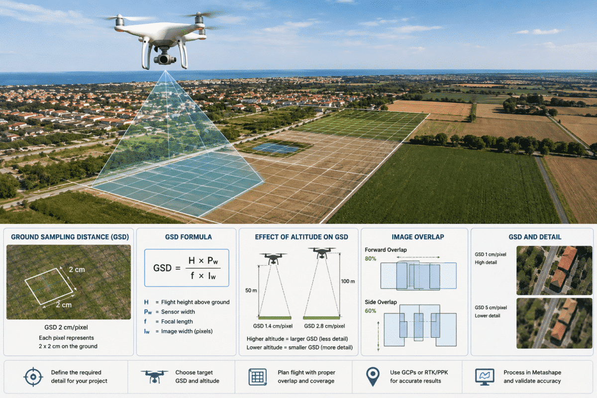
Ground Sampling Distance (GSD) is one of the most important parameters to understand when planning a drone photogrammetry survey for Agisoft Metashape.
GSD determines how much real-world ground area is represented by a single pixel in an aerial photograph. It directly influences the level of detail captured by the drone, the resolution of the resulting orthomosaic and DEM, the number of images required and the amount of data that Metashape must process.
For example, a GSD of 2 cm/pixel means that one pixel in the source image represents approximately 2 × 2 cm on the ground.
Flying lower generally produces a smaller GSD and therefore more detailed imagery. Flying higher produces a larger GSD, reducing detail but allowing a larger area to be mapped with fewer images.
This guide explains Ground Sampling Distance for drone mapping, how GSD is calculated, how flight altitude affects it and how to choose an appropriate GSD when planning surveys for Agisoft Metashape.
What Is Ground Sampling Distance?
Ground Sampling Distance is the approximate distance on the ground represented by the distance between the centers of two adjacent image pixels.
GSD is normally expressed as:
- mm/pixel
- cm/pixel
- m/pixel
In drone mapping, centimeters per pixel is the most common unit.
For example:
- 1 cm/pixel GSD = each pixel represents approximately 1 cm on the ground.
- 2 cm/pixel GSD = each pixel represents approximately 2 cm.
- 5 cm/pixel GSD = each pixel represents approximately 5 cm.
A smaller GSD means higher spatial detail.
Why GSD Matters in Agisoft Metashape
Metashape reconstructs three-dimensional geometry by identifying and matching image features across overlapping photographs.
The amount of detail contained in those photographs therefore limits the detail that can ultimately be reconstructed.
GSD affects:
- Orthomosaic resolution
- Point cloud detail
- DEM and DSM resolution
- Visibility of Ground Control Points
- Ability to identify small objects
- Number of photographs required
- Processing time
- RAM and storage requirements
Choosing an unnecessarily small GSD can produce thousands of additional photographs without providing useful information for the project.
Choosing a GSD that is too large, however, may mean that important details were never captured and cannot be recovered during processing.
How Is GSD Calculated?
For a conventional nadir aerial photograph over approximately flat terrain, GSD can be estimated from camera geometry.
A useful formula is:
GSD = (H × Sensor Width) / (Focal Length × Image Width)
where:
- GSD = ground sampling distance
- H = distance between the camera and the ground
- Sensor Width = physical sensor width
- Focal Length = lens focal length
- Image Width = number of pixels across the image
An equivalent calculation can be made using the physical pixel size:
GSD = H × Pixel Size / Focal Length
The units must be kept consistent during the calculation.
Example GSD Calculation
Consider a drone camera with:
- Sensor width: 13.2 mm
- Image width: 5472 pixels
- Focal length: 8.8 mm
- Flight height above ground: 100 m
The approximate GSD is:
GSD = (100 × 13.2) / (8.8 × 5472)
This produces approximately:
0.0274 m/pixel = 2.74 cm/pixel
If the same camera flies approximately twice as high above the terrain, the GSD will also be approximately twice as large.
This relationship makes flight altitude one of the easiest variables to adjust when planning a mapping mission.
How Flight Altitude Affects GSD
For the same camera and lens:
Lower altitude = smaller GSD = more detail
Higher altitude = larger GSD = less detail
However, lower is not automatically better.
Flying very low means:
- Each image covers less ground.
- More flight lines are required.
- More photographs are captured.
- Processing time increases.
- RAM and storage requirements increase.
The objective should therefore be to capture the resolution required by the project rather than simply chasing the smallest possible GSD.
GSD Is Not Constant Over Uneven Terrain
The flight altitude entered into a drone mission is not necessarily the actual distance between the camera and every point on the terrain.
Imagine a drone flying at a constant altitude over a quarry.
The camera may be 100 meters above the highest area but 140 meters above the bottom of the excavation.
The images covering the quarry floor will consequently have a larger GSD than those covering the upper terrain.
This is why a Metashape project can have an average ground resolution while individual images and areas within the project have different effective GSD values.
For mountainous terrain, quarries and steep sites, terrain-following flight planning can help maintain a more consistent camera-to-ground distance.
What GSD Should You Use for Drone Mapping?
The correct GSD depends on the purpose of the project.
| Application | Typical Planning GSD Range |
|---|---|
| Detailed engineering / small features | 0.5–1.5 cm/pixel |
| Topographic drone survey | 1–3 cm/pixel |
| Construction monitoring | 1–3 cm/pixel |
| Stockpile measurement | 1–3 cm/pixel |
| Quarry / mining mapping | 2–5 cm/pixel |
| Large-area mapping | 3–10 cm/pixel |
| General visual documentation | Depends on required detail |
These are planning examples rather than universal accuracy specifications.
The correct GSD should be chosen according to the smallest feature that needs to be identified, the required deliverable resolution and the survey accuracy specification.
GSD Is Not the Same as Accuracy
This distinction is extremely important.
A GSD of 2 cm/pixel does not automatically mean that the survey has 2 cm positional accuracy.
GSD describes image resolution.
Survey accuracy depends on many additional factors, including:
- RTK or PPK positioning quality
- Ground Control Points
- Checkpoint accuracy
- Image geometry
- Camera calibration
- Image overlap
- Shutter speed and image sharpness
- Lens distortion
- Vertical datum configuration
- Photogrammetric bundle adjustment
You can therefore have a 1 cm GSD dataset that is several meters incorrectly georeferenced, or a larger-GSD dataset that is accurately positioned using high-quality survey control.
GSD and Image Overlap
GSD should never be planned independently from image overlap.
Metashape needs the same features to be visible in multiple photographs in order to reconstruct them reliably.
For general aerial surveys, Agisoft recommends approximately:
- 80% forward overlap
- 60% side overlap
Complex terrain and structures may benefit from additional overlap, cross-flight patterns or oblique imagery.
Reducing flight altitude to obtain a smaller GSD without adjusting flight-line spacing can therefore change the effective overlap and potentially compromise the dataset.
GSD and Ground Control Point Size
GSD is also useful when deciding how large Ground Control Point targets should be.
A target must occupy enough pixels in the aerial images to be identified and marked accurately.
Suppose your survey has a GSD of:
2 cm/pixel
A target feature 10 cm wide would occupy only approximately:
10 cm / 2 cm = 5 pixels
That may be too small for precise and repeatable marking.
A larger target covering substantially more pixels provides a much clearer center and reduces ambiguity when manually or automatically marking control points.
How GSD Affects Orthomosaic Resolution
After processing, Metashape can generate a georeferenced orthomosaic.
The natural output resolution is closely related to the effective resolution of the source imagery.
Creating an orthomosaic with a pixel size dramatically smaller than the original GSD does not create new ground detail.
For example, if the imagery contains approximately 3 cm/pixel of real ground information, exporting an orthomosaic at 0.5 cm/pixel mainly produces additional interpolated pixels rather than six times more measured detail.
For this reason, output resolution should remain realistic relative to the source dataset.
How GSD Affects Metashape Processing Time
A smaller GSD usually requires flying closer to the ground.
This reduces the footprint covered by each image, which means that more photographs are needed to map the same area.
More images generally increase:
- Alignment time
- Depth map processing
- Point cloud size
- DEM size
- Orthomosaic size
- RAM usage
- GPU workload
- Storage requirements
Survey planning is therefore also a data-management decision.
A GSD twice as small may create substantially more data than the project actually requires.
GSD and Small Feature Detection
One pixel is rarely enough to identify an object reliably.
If the smallest important feature in your project is 5 cm wide and you capture at 5 cm/pixel, the feature may occupy approximately one pixel.
Even though it theoretically appears in the image, it may not be recognizable or suitable for measurement.
Critical features should therefore span multiple pixels.
This is particularly important for:
- Survey targets
- Cracks
- Road markings
- Small pipes
- Edges and corners
- Infrastructure components
Planning a Drone Survey for Metashape
A practical workflow is to begin with the required deliverable rather than the maximum capability of the drone.
Step 1: Define the Required Detail
Determine the smallest object or terrain feature that needs to be visible or measured.
Step 2: Select the Target GSD
Choose a GSD that provides sufficient pixels across those features.
Step 3: Calculate Flight Height
Using the sensor dimensions, image resolution and focal length, calculate the camera-to-ground distance required to achieve the target GSD.
Step 4: Configure Image Overlap
For standard aerial mapping, approximately 80% forward and 60% side overlap is a useful Agisoft starting recommendation.
Step 5: Consider Terrain Variation
For steep terrain, consider terrain-following missions so the GSD remains more consistent across the project.
Step 6: Verify Flight Regulations and Safety
The required photogrammetric altitude must always remain compatible with local aviation regulations, obstacles and safe operating procedures.
Step 7: Process and Validate in Metashape
After the flight, process the images in Metashape and verify the final project using appropriate GCPs, RTK/PPK information and independent checkpoints where survey accuracy matters.
Metashape Mission Planning and Target GSD
Metashape Professional also includes mission-planning functionality for complex structures.
Within this workflow, the desired image resolution can be specified directly as a target GSD or as a capture distance from the reconstructed surface.
This illustrates an important principle: rather than choosing flight distance arbitrarily, photogrammetric acquisition can be planned around the spatial resolution required by the final project.
Common GSD Planning Mistakes
Always Flying as Low as Possible
More detail is useful only when the project needs it. Unnecessarily small GSD increases flight and processing workload.
Confusing GSD with Survey Accuracy
A small GSD does not guarantee accurate coordinates.
Ignoring Terrain Elevation
A fixed drone altitude over variable terrain creates variable GSD.
Reducing Image Overlap to Save Time
High-resolution images cannot compensate for poor photogrammetric geometry.
Exporting at Unrealistically Small Pixel Size
Upsampling an orthomosaic does not recreate detail that was absent from the original photographs.
Final Recommendations
Ground Sampling Distance should be selected before the drone leaves the ground, not after the images are imported into Metashape.
A good survey-planning workflow is:
- Define the required deliverable.
- Identify the smallest relevant features.
- Choose an appropriate target GSD.
- Calculate the necessary camera-to-ground distance.
- Set sufficient forward and side overlap.
- Account for changes in terrain elevation.
- Capture sharp and consistently exposed images.
- Use appropriate RTK, PPK or GCP control.
- Process the dataset in Agisoft Metashape.
- Validate real-world accuracy using checkpoints.
The objective is not to achieve the smallest possible GSD. The objective is to capture the right amount of image detail for the required survey accuracy and deliverables while keeping flight time and processing requirements efficient.
When GSD, overlap, camera geometry and georeferencing are planned together, Agisoft Metashape can transform the resulting drone imagery into accurate and efficient orthomosaics, point clouds, DSMs, DTMs and other professional geospatial products.
Frequently Asked Questions
What does GSD mean in drone mapping?
GSD stands for Ground Sampling Distance and describes the approximate ground distance represented by one image pixel.
Is a smaller GSD better?
A smaller GSD provides more spatial detail, but it also normally requires lower flight altitude, more photographs and more processing resources. The best GSD is the one appropriate for the project’s required detail.
Is 2 cm GSD equal to 2 cm accuracy?
No. A 2 cm/pixel GSD describes image resolution, not guaranteed positional accuracy. Survey accuracy also depends on control data, camera geometry, calibration, overlap and processing quality.
How does altitude affect GSD?
With the same camera and focal length, GSD increases approximately in proportion to camera-to-ground distance. Flying higher creates a larger GSD, while flying lower creates a smaller GSD.
What overlap should I use for Agisoft Metashape?
For general aerial photography, Agisoft recommends approximately 80% forward overlap and at least 60% side overlap as a starting point. Complex scenes may require more.
Can GSD vary inside the same drone survey?
Yes. If terrain elevation changes, the camera-to-surface distance also changes, producing different effective GSD values across the survey.
Can I improve GSD after the drone survey?
You can export an image or orthomosaic with smaller pixels, but this does not recreate real spatial detail that was not captured by the camera. True GSD is primarily determined during image acquisition.
Does Metashape use GSD for mission planning?
Yes. Metashape Professional’s mission-planning tools for complex structures can use a target GSD or a specified capture distance as the desired image-resolution parameter.
