LiDAR technology is transforming 3D mapping with laser-based precision, but what happens when you combine it with Agisoft Metashape’s photogrammetry capabilities? Many professionals are exploring hybrid workflows to maximize accuracy and model detail. In this article, we explain whether and how you can use LiDAR data in Metashape, and when hybrid processing makes sense.
Does Metashape Support LiDAR Data?
Agisoft Metashape does not process raw LiDAR waveforms or .las/.laz files as input for depth map generation. However, it does support importing point clouds generated from LiDAR scans, making it possible to align or merge them with photogrammetric data for enhanced models.
- Supported formats: .LAS, .LAZ, .PLY, .XYZ
- Use case: importing LiDAR point clouds for reference or fusion
- Limit: can’t generate DEMs or meshes directly from LiDAR-only in Metashape
Why Combine LiDAR and Photogrammetry?
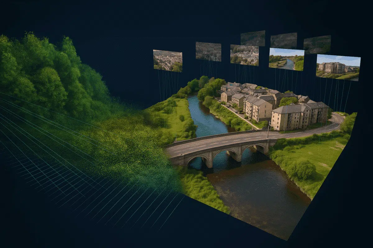
LiDAR excels at capturing structural details and elevation data, especially in areas with poor lighting, vegetation, or limited texture. Photogrammetry, on the other hand, delivers high-resolution texture and color information from RGB images. Together, they provide:
- Precision: LiDAR improves the geometric accuracy of terrain and surfaces
- Visual quality: Photogrammetry adds texture, color, and realism
- Completeness: Fill gaps where either system performs poorly
Hybrid Workflow Overview
A hybrid workflow typically includes these steps:
- Capture LiDAR data using a drone or terrestrial scanner
- Capture RGB images for photogrammetry processing
- Process LiDAR point cloud in a dedicated tool (e.g., CloudCompare, LAStools)
- Import the point cloud into Metashape for alignment or visualization
- Generate a mesh and texture using the photogrammetry data
How to Import LiDAR Point Clouds into Metashape
Follow these steps to bring external LiDAR data into your Metashape project:
- Open your Metashape project and go to File → Import → Import Point Cloud
- Select the format (.LAS, .PLY, .XYZ)
- Set the correct coordinate system (EPSG code)
- Optionally classify the points or set colors
Once imported, the LiDAR cloud can be used as a reference layer to compare or align with photogrammetric reconstructions.
Registering LiDAR and Photogrammetry Together
To combine both datasets effectively, you need to align them into the same coordinate space. Use:
- GCPs (Ground Control Points): place in both image and LiDAR data
- RTK/PPK GPS data: helps accurately georeference both datasets
- Manual alignment: when automatic methods fail
In Metashape, you can use the “Register Point Clouds” tool to align external clouds with your photogrammetric model.
Mesh Generation: Which Data Wins?
Metashape builds meshes using its own depth maps, not directly from imported LiDAR. However, the LiDAR cloud can guide model shaping and surface validation.
To leverage both sources:
- Use LiDAR to create a mesh in a third-party app (CloudCompare, MeshLab)
- Import that mesh into Metashape for texturing
- Compare it visually with a photogrammetric mesh
Best Tools to Combine with Metashape
- CloudCompare: for merging, aligning, and editing LiDAR clouds
- LASTools: for filtering and classification
- QGIS: for geospatial analysis
- MeshLab or Blender: for post-processing and rendering
Limitations to Consider
- Metashape cannot process LiDAR-only datasets from scratch
- LiDAR integration is limited to visualization and comparison, not full fusion
- Manual alignment may be needed without accurate GCPs
Use Cases for Hybrid Models
- Forestry: Use LiDAR to penetrate canopy and photogrammetry for color
- Infrastructure: Model power lines or bridges with detailed geometry
- Archaeology: Combine scan precision with texture mapping
- Disaster response: Map terrain changes quickly and accurately
Conclusion
While Agisoft Metashape doesn’t fully process LiDAR natively, it plays an essential role in hybrid workflows that combine LiDAR and photogrammetry. With the right preparation, you can create high-precision, visually rich 3D models that outperform either technology alone. Use LiDAR as a geometric backbone and Metashape’s photogrammetry to bring scenes to life.
The future of 3D reconstruction lies in smart integration—and hybrid workflows are leading the way.