Agisoft Metashape is one of the leading photogrammetry software solutions used worldwide in fields such as surveying, archaeology, mining, cultural heritage, and visual effects. One of the key reasons for its popularity is its compatibility with a broad range of file formats, allowing users to seamlessly import and export data across different platforms and workflows. Understanding what file formats Metashape can read and write is essential for professionals who want to optimize their projects and ensure interoperability with other software.
This article provides an in-depth overview of the formats supported by Metashape, divided into categories such as image inputs, point clouds, meshes, orthophotos, and digital elevation models. Whether you are a beginner or an advanced user, knowing these formats will help you make the most of your photogrammetry projects.
Image File Formats Supported by Metashape
At the core of every photogrammetry workflow are the source images. Metashape is designed to handle a wide variety of photographic data, making it highly versatile for different capture setups. The software can process both standard and professional image formats, including:
- JPEG (.jpg) – the most common format for consumer cameras and drones;
- TIFF (.tif, .tiff) – ideal for high-quality datasets, often used in professional photogrammetry;
- PNG (.png) – widely used for images that require lossless compression;
- RAW formats – including .CR2 (Canon), .NEF (Nikon), .ARW (Sony), and other vendor-specific formats, which provide maximum image detail and flexibility in processing;
- Multispectral and thermal images – depending on the sensor, Metashape can read radiometric TIFFs and specific camera outputs used in agriculture, forestry, and inspection.
This extensive image compatibility ensures that users can integrate data from drones, DSLR cameras, action cameras, or specialized sensors directly into their Metashape projects. For professional accuracy, TIFF and RAW formats are usually preferred, as they preserve maximum detail and metadata.
Point Cloud Formats: Import and Export
Once images are processed, Metashape generates dense point clouds, which can then be exported or integrated with external software like CAD, GIS, or BIM tools. Supported point cloud formats include:
- LAS / LAZ – standard formats widely used in LiDAR and surveying workflows;
- PLY – Polygon File Format, common for sharing point clouds and meshes across 3D applications;
- XYZ – plain text point cloud coordinates;
- PTS – point cloud format often used in laser scanning;
- E57 – an exchange format for 3D imaging data from laser scanners and photogrammetry software.
The availability of these formats makes Metashape a flexible hub for projects that involve LiDAR integration, GIS mapping, and 3D reconstruction. By supporting both industry standards and open formats, Metashape guarantees smooth interoperability.
Mesh and 3D Model Formats
Meshes are one of the most valuable outputs of Metashape, used in fields like architecture, archaeology, game design, and VFX. The software supports importing and exporting a wide range of 3D formats:
- OBJ – one of the most common 3D model formats, compatible with most design software;
- FBX – ideal for integration with animation, rendering, and game engines like Unreal Engine and Unity;
- DAE (Collada) – widely used in 3D exchange workflows;
- 3DS – Autodesk 3D Studio format, still used in legacy projects;
- PLY – for sharing 3D geometry and point data;
- STL – the most popular format for 3D printing applications.
Thanks to this variety, models generated in Metashape can be seamlessly integrated into CAD software, game engines, and 3D printing pipelines. For example, archaeologists may export models in OBJ for documentation, while engineers may use STL files for rapid prototyping.
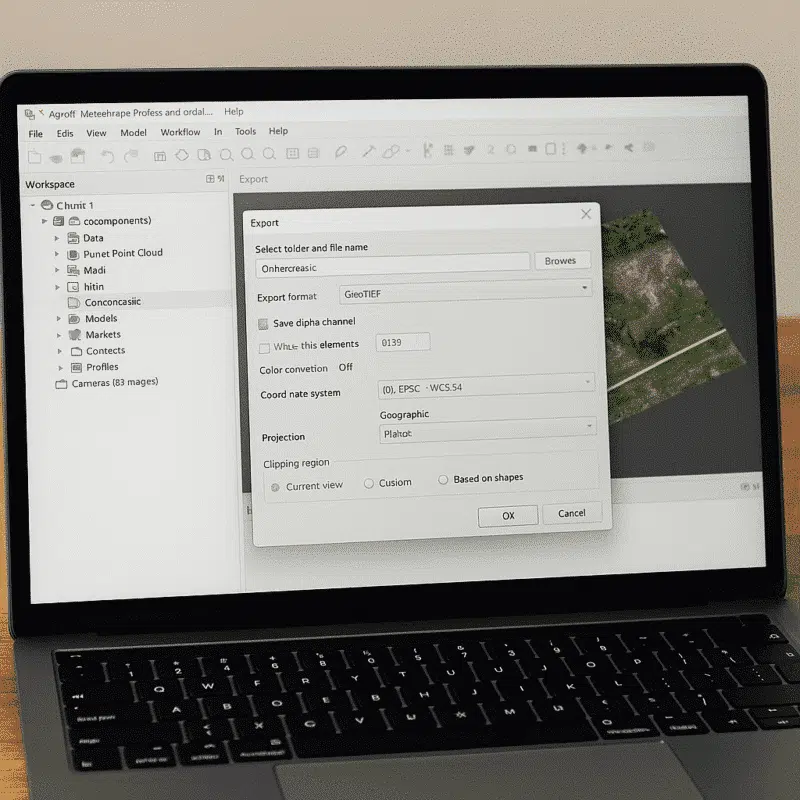
Digital Elevation Models (DEM) and Orthophotos
Geospatial projects often require accurate DEM and orthophoto outputs. Metashape provides extensive support for georeferenced raster data formats, including:
- GeoTIFF – the industry standard for orthophotos and DEMs, fully compatible with GIS platforms like QGIS and ArcGIS;
- JPEG and PNG – for lightweight exports of orthomosaics and DEMs;
- KMZ/KML – for visualization in Google Earth;
- ESRI ASCII Grid – for exchanging elevation data between GIS systems.
These formats ensure that surveyors, cartographers, and GIS specialists can incorporate Metashape outputs directly into their mapping and analysis workflows. The combination of orthophotos and DEMs makes it possible to create topographic maps, volume measurements, and terrain analysis with high precision.
Metadata, Coordinate Systems, and Export Flexibility
Beyond standard formats, Metashape also allows the export of camera positions, tie points, and coordinate system data in text-based formats such as CSV. This is crucial for projects that require integration with external processing tools or for documenting the accuracy of a reconstruction.
The software supports a wide range of coordinate systems and projections, ensuring compatibility with GNSS/RTK workflows, GCPs (Ground Control Points), and GIS data. This flexibility is particularly important in professional surveying and mapping applications, where precision and interoperability are non-negotiable.
Why Format Compatibility Matters in Photogrammetry
File format compatibility is not just a technical detail—it defines how smoothly a photogrammetry project can be integrated into broader workflows. For example:
- An architect may need to export a model in FBX to integrate with BIM software;
- A geologist may require DEMs in GeoTIFF to conduct slope analysis;
- A game designer may use OBJ or FBX to import realistic 3D assets into a game engine;
- A 3D printing specialist may directly export STL files for rapid prototyping.
This wide compatibility is one of the reasons Metashape remains a trusted tool in multiple industries, bridging the gap between raw image capture and final professional output.
Conclusion: Metashape as a Versatile Hub for Data Exchange
Agisoft Metashape is more than just a photogrammetry software—it is a versatile data hub that allows users to import and export in a variety of formats. From simple JPEG photos to high-resolution GeoTIFF orthophotos, from OBJ 3D models to LAS point clouds, the software ensures smooth interoperability with nearly every major platform used in surveying, design, GIS, and 3D modeling.
For professionals, this means greater flexibility, reduced workflow bottlenecks, and improved efficiency. For beginners, it ensures that starting a project in Metashape won’t mean being locked into a closed ecosystem.