Ground Control Points (GCPs) are essential for georeferencing and improving the accuracy of 3D models in Agisoft Metashape. But what if you don’t have access to high-precision GNSS data? You can use Google Earth as a practical and free tool to extract approximate GCP coordinates. This article walks you through the process of using Google Earth for GCP collection and integrating them into Metashape for better geospatial control.
What Are GCPs and Why Do They Matter?
Ground Control Points are physical markers with known coordinates that are visible in your aerial or ground images. In photogrammetry software like Metashape, GCPs help to:
- Anchor your model to real-world locations
- Improve spatial accuracy (both horizontal and vertical)
- Correct scale and orientation
- Ensure alignment with GIS data and maps
Can Google Earth Be Used for GCPs?
Yes, with some limitations. Google Earth’s coordinate accuracy is sufficient for low- to medium-precision applications (±5–10 meters). While not suitable for high-end surveying or engineering, it’s great for:
- Educational projects
- Proof-of-concept reconstructions
- Drone hobbyists or archaeology surveys
- Environmental mapping without GNSS equipment
Step-by-Step: How to Extract GCPs from Google Earth
1. Launch Google Earth Pro
Download and open Google Earth Pro (free desktop version, not the web version) from https://www.google.com/earth/versions/. Zoom in to your project area and enable high-resolution satellite imagery.
2. Identify Natural or Artificial Markers
Look for identifiable points visible in both your drone images and the satellite imagery. These could be:
- Street corners
- Building edges
- Road markings
- Tree shadows or fence posts
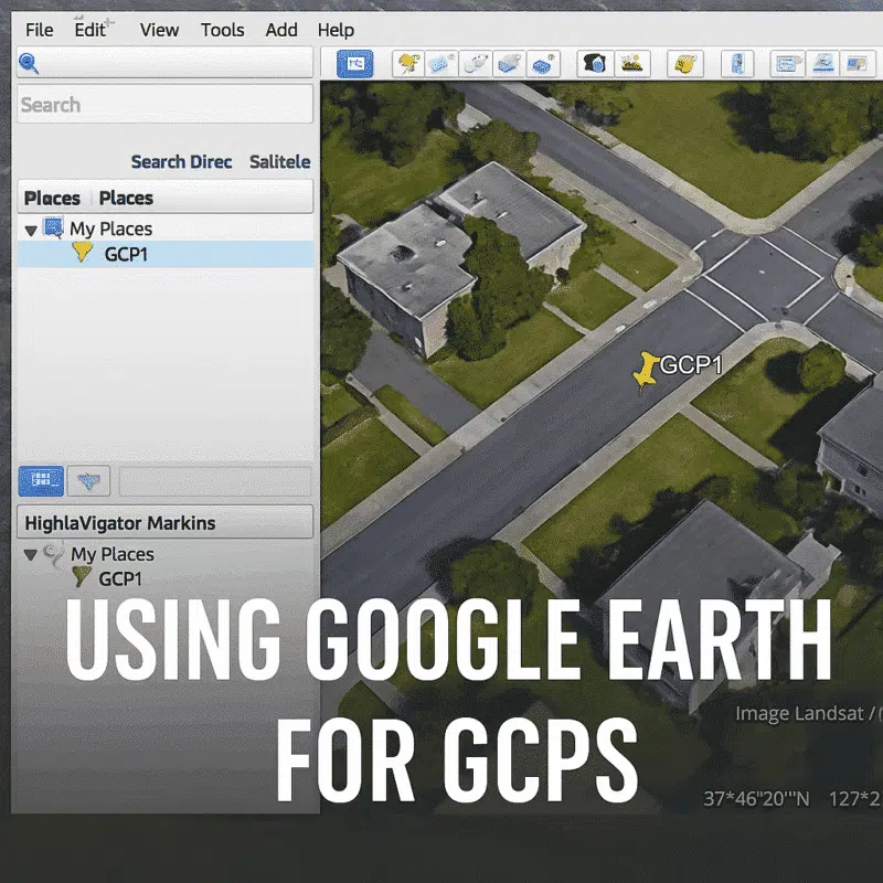
3. Add a Placemark
- Click the Placemark icon (Pushpin)
- Give it a unique name like “GCP1”
- Zoom in for maximum precision and click directly on your chosen point
- Google Earth will generate latitude, longitude, and altitude
4. Export GCP Coordinates
Repeat the process for all GCPs. Then export your placemarks:
- Go to My Places
- Right-click the folder with your GCPs → Save Place As…
- Export as KML or KMZ file
5. Convert KML to CSV (Optional)
Metashape doesn’t read KML directly as GCPs. You need to convert it to a CSV file:
- Use GPS Visualizer or MyGeodata Converter
- Export in CSV format: Name, Latitude, Longitude, Altitude
Importing GCPs into Metashape
- In Metashape, go to the Reference Pane
- Click the Import Markers button
- Select your CSV file
- Assign the correct column order (e.g., Name, Lon, Lat, Alt)
- Check the coordinate system (WGS84 or UTM)
Markers will appear in your model, but you still need to manually place them on the images.
Manually Tag GCPs on Images
For each GCP:
- Select the marker in the Reference pane
- Open 2–4 images where the GCP is clearly visible
- Use the crosshair tool to mark its exact location
- Repeat for each GCP
Optimize Camera Alignment
Once all GCPs are placed:
- Right-click the chunk → Optimize Cameras
- Check all parameters (f, cx, cy, k1–k4, p1, p2, etc.)
- Click OK to refine the camera model using the GCPs
Expected Accuracy When Using Google Earth GCPs
Accuracy depends on the resolution of satellite imagery and the clarity of your image dataset. You can expect:
- Horizontal accuracy: ~5 meters
- Vertical accuracy: 10–15 meters (depending on terrain model)
This is acceptable for general mapping and visualization purposes, but not for cadastral, engineering, or precision agriculture workflows.
Tips to Improve Accuracy
- Use consistent zoom and tilt angles in Google Earth
- Double-check elevation mode (clamped to ground vs absolute)
- Use at least 5 GCPs evenly spread across the scene
- Set vertical datum correctly (orthometric vs ellipsoidal)
Conclusion
Using Google Earth for GCPs is a convenient and accessible method for improving photogrammetric results in Agisoft Metashape—especially when GNSS equipment is not available. While the resulting accuracy won’t meet survey-grade standards, it’s a powerful tool for hobbyists, educators, and exploratory researchers. By following the workflow above, you can anchor your models to the real world with minimal setup and no additional hardware.
Looking to take your models to the next level? Consider pairing Google Earth GCPs with drone flight logs or integrating with QGIS for better geospatial management.