Agisoft Metashape is one of the most powerful and widely used photogrammetry tools in the world. From drone mapping to architectural 3D modeling, its features support a wide range of industries. In this guide, we’ll explore Metashape’s most important capabilities—including dense cloud creation, digital elevation models (DEM), orthomosaics, and more—explaining what each does and when to use it.
1. Photo Alignment
This is the first step in every Metashape workflow. The software detects common points across overlapping images and calculates the camera positions and orientations.
- Outputs: Sparse point cloud, camera calibration data
- Use Cases: All projects—indoor, outdoor, aerial, or close-range
2. Dense Cloud Generation
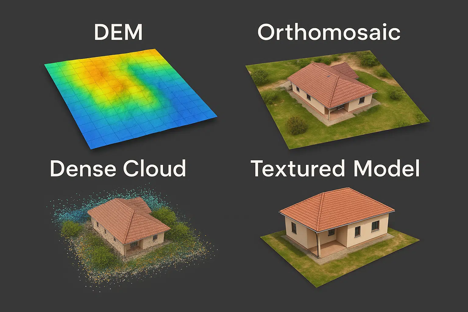
Metashape uses depth maps to generate a dense point cloud, which is a highly detailed 3D representation of the scanned scene. Each point carries spatial information and sometimes RGB color.
- Quality options: Low to Ultra High
- GPU acceleration supported (CUDA/OpenCL)
- Editable (classification, filtering)
3. Digital Elevation Model (DEM)
A Digital Elevation Model is a rasterized 2.5D surface that represents the terrain’s height, excluding or including above-ground objects depending on how it’s generated.
- Types: DSM (Surface), DTM (Terrain)
- Output: GeoTIFF or other GIS-compatible formats
- Use Cases: Topography, flood modeling, slope analysis
4. Orthomosaic Generation
An orthomosaic is a geometrically corrected, high-resolution image composed from many photos. It preserves scale and is map-accurate, suitable for GIS applications.
- Output: GeoTIFF, JPEG, KMZ
- Use Cases: Land use analysis, agriculture, construction
- Includes true color and optional NDVI or multispectral data
5. 3D Mesh and Textured Models
Metashape can build high-quality polygonal models from dense point clouds or depth maps. These can be textured for realistic visualization or exported to 3D modeling software.
- Formats: OBJ, FBX, 3DS, PDF, PLY
- Use Cases: Architecture, gaming, archaeology, cultural heritage
- UV mapping and texture baking supported
6. Camera Calibration & Optimization
Metashape automatically estimates internal camera parameters but also allows users to input or optimize values for better accuracy—ideal when using known calibration certificates or specialized lenses.
- Supported: Fisheye, perspective, spherical lenses
- Essential for metric accuracy in survey-grade applications
7. Ground Control Points (GCPs) & Georeferencing
Metashape supports importing GCPs from CSV files to improve geolocation accuracy. It also supports RTK/PPK data from drones and can transform coordinate systems for GIS workflows.
- Formats: WGS84, UTM, ECEF, local systems
- Use Cases: Surveying, cadastral mapping, engineering
8. Cloud and Batch Processing
Using Python scripting or network licenses, users can automate jobs, run headless processing, or use Metashape in the cloud. It supports multi-machine processing via network tasks.
- Command-line scripting for server-side processing
- Cloud services like EC2 or Google Cloud supported
9. Map Export and GIS Integration
Metashape supports exporting to GIS-compatible formats like GeoTIFF, Shapefile, and LAS. Orthomosaics and DEMs can be directly imported into QGIS, ArcGIS, or CAD tools.
- Supports coordinate transformations
- Ideal for integrating into urban planning, forestry, and hydrology models
10. Other Features
- Multispectral processing (RedEdge, Altum)
- Thermal imaging compatibility (FLIR, DJI H20T)
- Scriptable UI and custom tool creation
- Support for headless Linux environments
Conclusion
Agisoft Metashape offers a robust set of tools for photogrammetry, GIS, 3D modeling, and remote sensing. Whether you need a dense cloud for a construction site, a DEM for hydrology analysis, or an orthomosaic for agriculture, Metashape delivers accuracy and flexibility across every stage of the pipeline. Mastering its core features is essential to get the most value from your data and maximize productivity in any 3D or mapping project.