The release of Agisoft Metashape 2.2 has brought significant improvements in handling terrestrial laser scans (TLS). These datasets, captured by ground-based LiDAR systems, are crucial for industries such as construction, cultural heritage preservation, mining, and engineering. This article provides a comprehensive overview of how to import, process, and refine TLS data in Metashape 2.2, making it accessible both for beginners and professionals.
What Are Terrestrial Laser Scans?
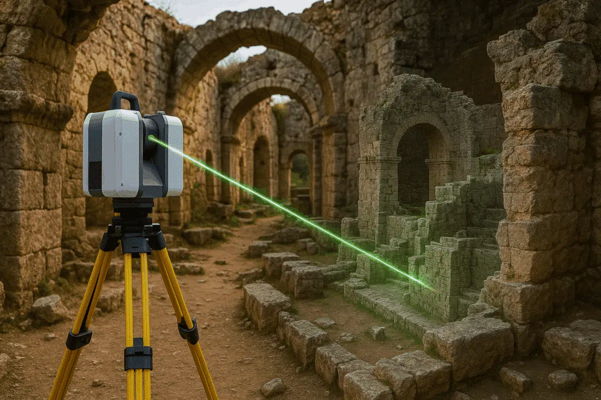
Unlike aerial LiDAR, terrestrial laser scanning is performed from fixed ground stations using tripod-mounted sensors. The scanner emits laser beams in multiple directions, measuring the distance to surfaces and creating dense point clouds that represent objects and environments with millimeter-level accuracy.
These point clouds are particularly useful for applications such as:
- Architecture and Engineering: Capturing precise measurements of buildings, bridges, and infrastructure.
- Archaeology and Heritage: Documenting historical sites and artifacts with exceptional detail.
- Mining and Geology: Monitoring tunnels, slopes, and geological formations.
Agisoft Metashape 2.2 enhances workflows by allowing users to seamlessly integrate TLS data into their photogrammetry projects, enabling both standalone processing and hybrid approaches that combine laser scans with photographic imagery.
Importing Terrestrial Laser Scans into Metashape 2.2
The first step in processing TLS data is importing the raw scans. Metashape 2.2 supports industry-standard formats such as LAS, LAZ, and E57. The process is straightforward:
- Open Agisoft Metashape 2.2 and create a new project.
- Navigate to File > Import > Import Laser Scans.
- Select the relevant scan files and assign the appropriate coordinate reference system (CRS).
Once loaded, the scans appear in the workspace as dense point clouds. Each scan retains its station position, which can be used for precise alignment across multiple scans.
Aligning and Registering Laser Scans
One of the most critical steps in TLS processing is scan alignment. Multiple scans captured from different tripod positions must be registered to form a complete and accurate model of the scene.
In Metashape 2.2, alignment is achieved through:
- Target-Based Registration: Using spheres, checkerboards, or coded markers placed in the environment during scanning.
- Feature-Based Alignment: Automatically matching geometric features across overlapping scans.
- Manual Adjustments: Fine-tuning alignment when automated methods are insufficient.
Successful registration ensures that the final dataset is coherent, with minimal misalignment errors across overlapping areas.
Optimizing Point Clouds in Metashape 2.2
After alignment, the TLS data often requires optimization. Raw scans may include noise, redundant points, or irrelevant objects. Metashape 2.2 offers several tools for refinement:
- Point Classification: Automatically separate ground, vegetation, and structural elements.
- Noise Filtering: Remove stray reflections from glass, water, or moving objects.
- Decimation: Reduce point density while maintaining accuracy to improve processing speed.
These steps ensure that subsequent outputs—such as meshes, DEMs, or orthophotos—are both accurate and efficient to generate.
Generating 3D Models and Deliverables
Once the terrestrial laser scans are processed, users can convert the data into a variety of deliverables. Metashape 2.2 enables the creation of:
- Meshes: Triangulated surfaces representing the scanned environment.
- Digital Elevation Models (DEM): Accurate ground surfaces useful for geospatial analysis.
- Textured Models: When combined with photographic data, detailed photorealistic 3D reconstructions are possible.
- Cross-Sections and Profiles: Essential for engineering and monitoring applications.
These outputs can be exported to GIS, CAD, or BIM platforms, ensuring compatibility with professional workflows.
Applications of TLS Data in Metashape
The ability to process TLS data in Metashape 2.2 opens new possibilities across various sectors:
- Cultural Heritage: High-resolution documentation of monuments and archaeological sites for preservation and research.
- Construction and Engineering: As-built surveys, deformation monitoring, and clash detection in complex projects.
- Mining: Volume calculations, slope stability analysis, and safety assessments.
- Forestry and Environment: Detailed vegetation structure analysis and habitat modeling.
The versatility of TLS data, combined with Metashape’s robust processing tools, ensures accurate results suitable for both technical analysis and visual communication.
Tips for Efficient TLS Processing
Processing large terrestrial laser scan datasets can be resource-intensive. To improve efficiency, consider these best practices:
- Use powerful hardware: A workstation with a strong GPU, SSD storage, and high RAM capacity significantly improves processing speed.
- Organize scans by station: Keeping scans grouped by location simplifies alignment and error checking.
- Combine with imagery: Adding DSLR or drone photos enriches the final outputs with high-quality textures.
- Leverage batch processing: Automate repetitive tasks with Python scripting in Metashape.
Conclusion: Unlocking the Power of Terrestrial Laser Scans
With the release of Agisoft Metashape 2.2, processing terrestrial laser scans has never been more streamlined. From importing raw TLS data to generating high-quality 3D models, the software provides a complete workflow tailored to diverse industries. Whether you are documenting heritage sites, monitoring construction projects, or analyzing geological formations, Metashape ensures precision and reliability at every step.
To fully leverage the potential of TLS processing, explore Metashape’s advanced features, combine laser scans with imagery, and continuously refine your workflow. By doing so, you will unlock new possibilities for accurate 3D reconstruction and data analysis.