AGRICULTURE AND FORESTRY WITH AGISOFT METASHAPE

Agisoft Metashape for Agriculture and Forestry

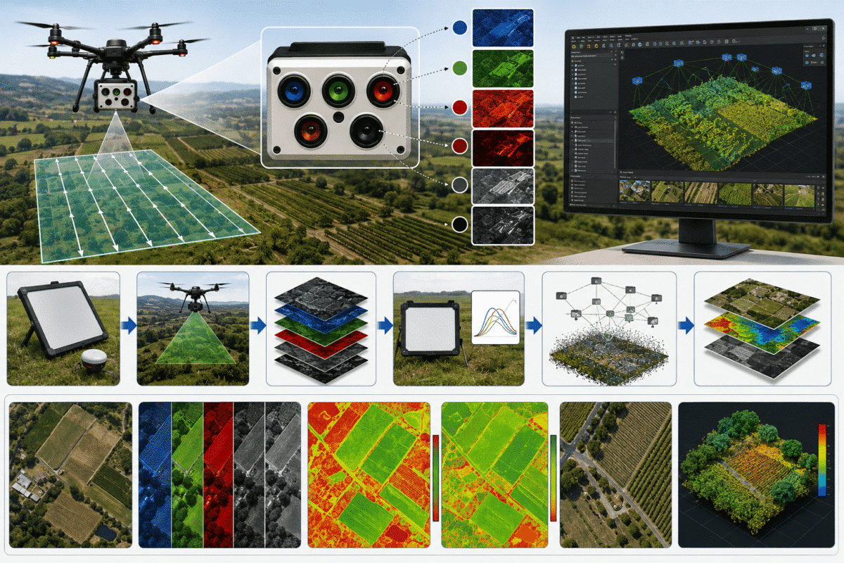
Turn overlapping RGB or multispectral images into georeferenced maps, surface models and vegetation-index products—with workflows designed around calibration, spatial control, repeatability and field validation.

Explore the Workflow

Compare Editions

04
DATA PRIORITIES

RADIOMETRIC CONSISTENCY

Sensor, illumination and calibration control

SPATIAL REFERENCE

Coordinates, control and checkpoints

FIELD VALIDATION

Ground observations and reference data

REPEATABILITY

Comparable capture and processing methods
CAPTURE. CALIBRATE. MAP. INTERPRET.

Drone Emotions Srl combines official Agisoft Metashape Professional licensing with practical guidance for agronomists, growers, forestry teams, environmental researchers and UAV service providers.

FROM IMAGERY TO A DEFENSIBLE MANAGEMENT LAYER

Start with the management question—not with the index

A useful project begins with a defined decision: document field condition, compare growth zones, inspect emergence, map drainage patterns, delineate canopy, estimate surface structure or prioritize field checks. That question determines the sensor, ground sampling distance, flight timing, calibration method, spatial reference and output.

Agisoft Metashape Professional can reconstruct georeferenced RGB and multispectral products, but biological meaning does not come from processing alone. Vegetation indices and canopy metrics should be interpreted with field observations, agronomic or forestry expertise and documented uncertainty.

✓ Define the field, forest or research decision first

✓ Match sensor bands and resolution to the question

✓ Plan calibration, overlap and spatial reference before capture

✓ Use checkpoints and field observations for validation

✓ Preserve acquisition and processing metadata

WHO THIS PAGE SUPPORTS

Agriculture, forestry and environmental teams

Agronomists and crop consultants
Creating mapped evidence to guide scouting, zoning and field interpretation.

Growers, vineyards and orchards
Documenting spatial variability and comparing repeat surveys under controlled conditions.

Forestry and conservation teams
Mapping canopy extent, surface structure, change and areas for field inspection.

UAV survey providers
Delivering traceable RGB, multispectral, elevation and vector products.

Universities and research institutions
Designing repeatable experiments with documented calibration and validation.

AGRICULTURE AND FORESTRY OUTPUTS

Build each product for a defined decision

One image survey can support several deliverables, but a visually attractive map, a reflectance product and a validated management layer are not interchangeable. Record the purpose, units, resolution, reference and limitations of every output.

01

RGB orthomosaics

Create georeferenced visual maps for field context, crop rows, gaps, drainage features, access routes, canopy boundaries and inspection planning.

02

Reflectance mosaics

Process supported multispectral imagery with sensor metadata, calibration-panel data and irradiance information to produce band-aligned reflectance products.

03

Vegetation indices

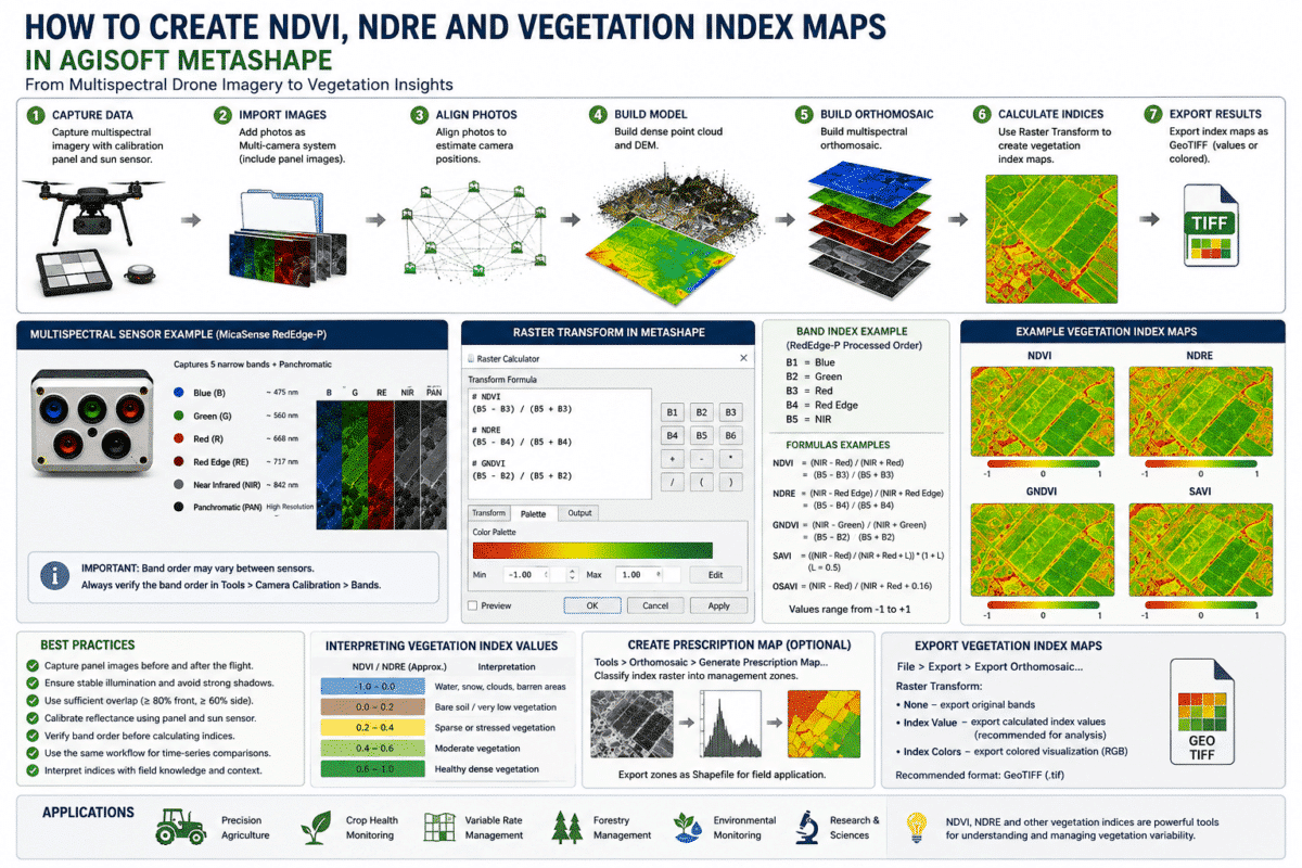
Calculate NDVI, NDRE or a justified custom formula from appropriate calibrated bands, then classify or export results for further analysis.

04

Terrain and canopy layers

Generate point clouds and elevation products for terrain, drainage and canopy analysis, with ground classification and validation suited to site conditions.

END-TO-END AGRICULTURE AND FORESTRY WORKFLOW

Six decisions connect acquisition to field action

Reliable interpretation begins before the flight and continues after export. Treat sensor choice, calibration, geometry, processing, validation and archiving as one connected method.

01 — DECISION

Define the question

State the crop, stand, date, decision, expected user, minimum detectable feature and required output before choosing a sensor or flight plan.

02 — SENSOR AND REFERENCE

Select bands and control

Choose RGB, multispectral or thermal data for the intended measurement, then define coordinates, GCPs or checkpoints and the calibration evidence required.

03 — ACQUISITION

Control the capture

Plan ground sampling distance, overlap, exposure, sun and wind conditions, calibration-panel images and repeatable timing. Record deviations in the field log.

04 — CALIBRATION

Group, calibrate and align

Confirm band grouping, sensor metadata and panel values, apply reflectance calibration when required, align imagery and inspect coverage and camera geometry.

05 — PRODUCTS

Build and evaluate

Generate the required surface, orthomosaic or index layer, review seamlines and artefacts, and check spatial or radiometric consistency before export.

06 — VALIDATION

Interpret and archive

Compare outputs with checkpoints and field evidence, document uncertainty and thresholds, and preserve imagery, metadata, settings and validated derivatives.

PROCESSING STRATEGIES BY DATA TYPE

Use the workflow that matches the measurement

RGB mapping, calibrated multispectral analysis and forest-structure modelling answer different questions and require different validation evidence.

01 — RGB MAPPING

Map visible condition and context

Use high-overlap RGB imagery for orthomosaics, surface models and visual interpretation of crop rows, gaps, lodging, drainage, canopy extent and access. Do not infer spectral properties that the sensor did not measure.

02 — MULTISPECTRAL REFLECTANCE

Calibrate before calculating

Use supported band sets, correct calibration-panel values and irradiance metadata where available. Calculate indices from the calibrated source bands—not from a visually pan-sharpened derivative.

03 — FOREST STRUCTURE

Separate canopy evidence from estimates

Use surface and point-cloud products to describe the visible upper canopy. Tree counts, canopy height, biomass or carbon estimates require appropriate downstream methods, field samples and an explicit treatment of occlusion and uncertainty.

INTERPRETATION AND DATA INTEGRITY

A colorful vegetation map is not automatically a field diagnosis

NDVI, NDRE and other indices describe relationships between selected spectral bands. Their values can change with canopy density, exposed soil, crop stage, illumination, sensor response, radiometric calibration, atmosphere and processing choices—not only with plant health.

Use mapped patterns to guide inspection and sampling, then interpret them with crop or forest knowledge and field evidence. If surveys are compared over time, keep acquisition and processing as consistent as practical and document every change that could influence the result.

Open Vegetation Map Guide

QUALITY GATES

Evidence to preserve with each map

✓ Sensor, lens and firmware information

✓ Flight date, time, altitude and weather notes

✓ Calibration-panel values and images

✓ Coordinate system, GCPs and checkpoints

✓ Band formula, palette and classification thresholds

✓ Processing settings and software version

✓ Field observations and sampling method

✓ Known limitations and validation results

CHOOSE THE CONFIGURATION FROM THE WORKFLOW

Professional is the working edition for geospatial and multispectral projects

Agriculture and forestry workflows commonly require georeferencing, control points, orthomosaics, elevation products, multispectral processing, vegetation indices or automation. These are Metashape Professional capabilities; the remaining choice is how the license should be assigned and used.

DEDICATED WORKSTATION

Professional Node-Locked

A perpetual Professional license assigned to one computer at a time and transferable through the supported deactivation and activation procedure.

✓ Geospatial and multispectral tools

✓ Suitable for a dedicated operator

✓ Rehostable between workstations

TEAMS AND SHARED LABS

Professional Floating

A license server provides concurrent access to installed Professional workstations. The number of simultaneous sessions is limited by the Floating seats purchased.

✓ Professional edition only

✓ Shared use across a team

✓ One seat per simultaneous session

EDUCATION AND RESEARCH

Professional Educational

Discounted Professional licensing for qualifying accredited institutions and eligible students or staff conducting non-commercial education or research.

✓ Full Professional feature set

✓ Accreditation-based eligibility

✓ Non-commercial use restriction

Need to test a representative dataset first? Start a Professional trial, then review the edition and licensing comparison.

PRACTICAL AGRICULTURE AND FORESTRY GUIDES

Continue with the sensor and output you use

Use these focused resources for vegetation indices, supported MicaSense workflows and the handoff from Metashape products to validated forest analysis.

NDVI and NDRE vegetation maps created in Agisoft Metashape Professional

VEGETATION INDICES

Create NDVI, NDRE and vegetation maps

Configure band formulas, use appropriate calibrated inputs, build interpretable palettes and export index products for validated downstream analysis.

MicaSense RedEdge-P multispectral imagery processed in Agisoft Metashape Professional

MICASENSE REDEDGE-P

Complete RedEdge-P processing workflow

Follow the path from image import and band organization through reflectance calibration, alignment, orthomosaics, indices and export.

MicaSense Altum multispectral and thermal processing workflow in Agisoft Metashape Professional

MICASENSE ALTUM

Altum reflectance-calibration workflow

Review multispectral grouping, calibration panels, irradiance information, orthomosaic production and careful treatment of the thermal band.

Forest canopy mapping and tree inventory workflow using Agisoft Metashape outputs

FOREST MONITORING

Forest inventory and tree-counting handoff

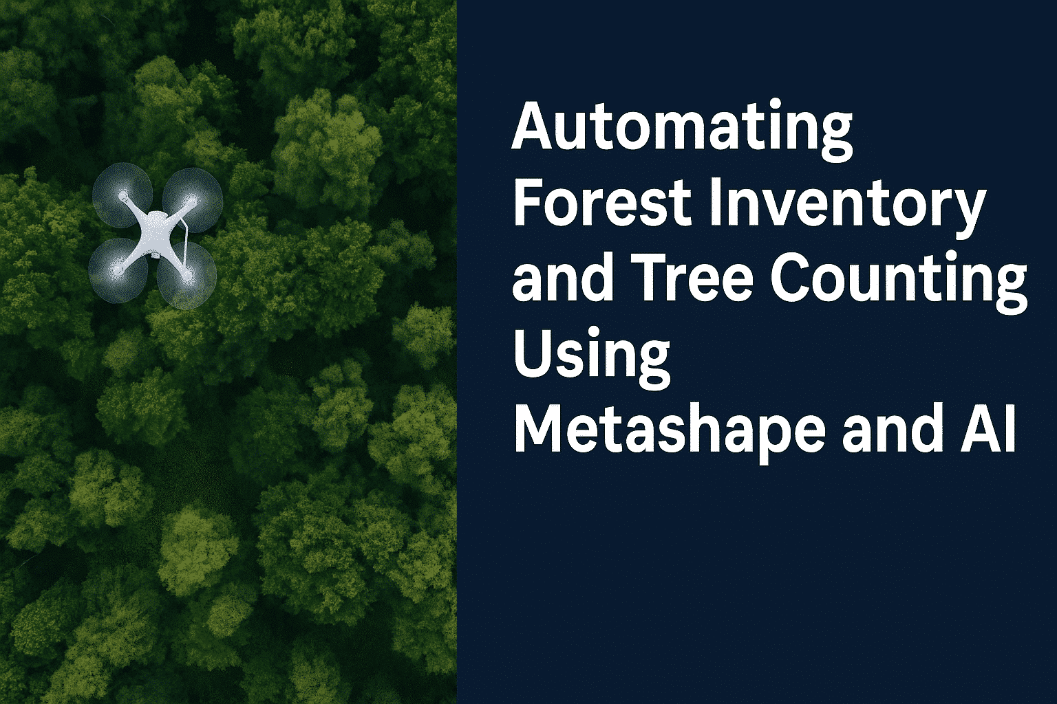
Understand how Metashape surface and orthomosaic products can feed external canopy and tree-detection methods that still require field validation.

RESEARCH, METHODS AND LIMITATIONS

Connect mapped patterns to verifiable evidence

Use transparent methods, published research and field validation to explain what each map measures, what it does not establish and how its uncertainty affects the intended decision.

APPLIED PHOTOGRAMMETRY RESEARCH

Plan validation before processing

Use practical research resources to define readiness, validation evidence and method limitations before a dataset becomes a production or research deliverable.

SCIENTIFIC REFERENCES

Follow independent publications

Review publications that cite Agisoft Metashape or this website, then follow each original source to understand its sensor, dataset, method, scope and limitations.

OFFICIAL AGISOFT RESOURCES

Continue with current sensor guidance

These external resources are published by Agisoft LLC. Confirm that instructions, supported sensors and interface references correspond to the Metashape version and camera configuration used for the project.

MicaSense RedEdge-MX workflow

Review the official import, calibration-panel, irradiance-sensor, reflectance-calibration and orthomosaic steps for supported RedEdge-MX datasets.

DJI Phantom 4 Multispectral

Follow Agisoft’s official workflow for organizing, calibrating, aligning and processing imagery from the DJI Phantom 4 Multispectral system.

Metashape Professional manual

Consult the current Professional manual for multispectral imagery, reflectance calibration, raster calculations, orthomosaics, elevation products and export settings.

FREQUENTLY ASKED QUESTIONS

Agisoft Metashape agriculture and forestry questions

Use these answers for initial planning, then confirm crop, forest, sensor, survey and validation requirements with the responsible specialists.

For the workflows described on this page, Professional is the appropriate edition. It provides georeferencing, control points, orthomosaics, elevation models, measurements, multispectral processing, raster calculations and advanced automation capabilities. Standard is designed for core 3D reconstruction and does not provide the complete geospatial and multispectral toolset required here.

No. An index maps a mathematical relationship between selected spectral bands. A low or high value can be influenced by plant density, crop stage, exposed soil, illumination, sensor response, calibration and other factors. Use vegetation maps to identify patterns and prioritize scouting, then interpret them with field observations, sampling and qualified agronomic knowledge.

It is important when the objective requires reflectance products or comparison across changing illumination, dates or sites. Use valid calibration-panel data and supported sensor or irradiance metadata where available, and document the method. Uncalibrated imagery may still support visual inspection, but quantitative comparison becomes less defensible.

Only after controlling and documenting the factors that affect comparability. Keep the sensor, settings, altitude, ground sampling distance, time of day, illumination, calibration method, coordinate reference, processing version and formula as consistent as practical. Validate that apparent change exceeds spatial, radiometric and reconstruction uncertainty before interpreting it as biological change.

Yes, a canopy height model can be derived by comparing an appropriate canopy surface model with a suitable ground-terrain model. The quality of the result depends on georeferencing, surface reconstruction, ground classification and whether the ground is actually visible beneath the canopy. Dense vegetation can conceal the terrain, so field or external elevation data may be required.

Metashape can produce orthomosaics, point clouds and surface models that feed external tree-detection or predictive workflows. The count or estimate is not created by photogrammetry alone and should be validated with field plots and a method appropriate to species, canopy closure and sensor resolution. Aerial imagery primarily describes the visible upper canopy and may not reveal understory or obscured stems.

Accurate RTK or PPK positions can reduce the amount of ground control required, but they do not remove the need for independent validation. Use well-distributed checkpoints to test the complete system, including camera calibration, time synchronization, coordinate transformations, lever-arm offsets and processing choices. The required evidence depends on the accuracy claimed for the deliverable.

A Professional Node-Locked license suits one assigned workstation at a time. Professional Floating licenses support shared concurrent access across configured workstations, with one seat required for each simultaneous session. Qualifying accredited institutions and eligible students or staff may use Educational Professional licenses only for permitted non-commercial education and research.

LICENSING, TRAINING AND WORKFLOW GUIDANCE

Describe the decision and dataset before selecting the configuration

Tell us the crop or forest application, sensor and bands, image count, calibration data, spatial-reference method, required outputs, comparison dates, hardware and number of users. We can help identify the appropriate Professional license model and next technical resource.

Request Project Guidance

Drone Emotions Srl
Agisoft Authorized Reseller & Training Center
[email protected]
800 984 535 · +39 347 433 3302